
Aegaea

Quick links

↑ ↓ to choose · Enter to open · Esc to closeSearch stays in your browser.

Full Planning Drainage Strategy

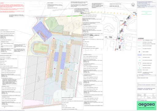
A full planning surface water drainage strategy is a detailed review of how rainfall landing on your site will be managed, supported by calculations and a scaled drainage layout showing pipe diameters, invert levels, connections and discharge rates. You need one if your development creates new buildings or reduces green areas on the site, and national policy in England requires SuDS wherever possible. Aegaea produces these for schemes from single dwellings through to 500 unit developments, solar farms, schools and leisure facilities.

Do I Need A Surface Water Drainage Strategy For Full Planning?

If you’re proposing a development in the UK that includes constructing a new building or reducing the number of ‘green’ areas on your site, you’ll likely require a full planning surface water drainage strategy (SWDS).

National Policy also states that all developments need to consider how surface water is mitigated on their site and use SuDS where possible.

Without a surface water drainage strategy, your planning application could be rejected.

You’ll then need to resubmit, which will cost time and money, or have a retrospective planning application enforced.

A surface water drainage strategy, in its simplest form, assesses the amount of rainfall that could fall on a site while assessing the type of surfaces that will be there.

Therefore, it analyses the impacts the runoff rate will have on the site and surrounding area. It then provides mitigation measures (such as SuDS products) to store or move this water elsewhere to prevent flooding.

SuDS (Sustainable Drainage Systems), are devices or products that mimic the natural water mitigation measures, such as ponds or soakaways.

All major applications should be accompanied by a site-specific drainage strategy that demonstrates the use of SuDS unless you can show it’s impractical or inappropriate for your site.

A surface water drainage strategy is not just restricted to major developments. It can also apply to minor developments, like house extensions.

Common questions

Here are answers to common questions about this work. If you would like to discuss your own site, we can help you work out what is needed.

The overall outcome of a sustainable drainage strategy is to control a water source on your development by mimicking natural processes. The end goal is to provide a ‘betterment’ to the area and reduce the impact of your development on the surrounding site.

To satisfy planning, there are many Sustainable urban Drainage Systems (SuDS) that can be used to support achieving this goal. Each solution can be assessed on the 4 key SuDs benefits, but one solution does not need to meet all 4. You can use a variety of solutions together to meet these benefits. The 4 parts to assess the suitability and benefit of a SuDS solution are;

  • Water Quantity
  • Water Quality
  • Amenity
  • Biodiversity

The National Planning Policy Framework of 2019 introduced the use of SuDS as a requirement unless it is deemed to be inappropriate for the development.

When determining any planning applications, local planning authorities should ensure that flood risk is not increased elsewhere. Where appropriate, applications should be supported by a site-specific flood-risk assessments. Development should only be allowed in areas at risk of flooding where, in the light of this assessment (and the sequential and exception tests, as applicable) it can be demonstrated that:

a) within the site, the most vulnerable development is located in areas of lowest flood risk, unless there are overriding reasons to prefer a different location;

b) the development is appropriately flood resistant and resilient such that, in the event of a flood, it could be quickly brought back into use without significant refurbishment;

c) it incorporates sustainable drainage systems, unless there is clear evidence that this would be inappropriate;

d) any residual risk can be safely managed; and

e) safe access and escape routes are included where appropriate, as part of an agreed emergency plan.

This new policy means it’s highly encouraged to use sustainable drainage systems, however, there are limited exemptions.

A common exemption would be an extension atop the existing built footprint. If it doesn’t exceed the existing building footprint and will connect into former/existing roof drainage, it can be exempt from needing a new SuDS strategy.

Each application is unique and although this is a common exemption, we would strongly recommend liaison with your Local Planning Authority and Lead Local Flood Authority before proceeding with similar projects.

The main difference between outline planning and full planning is the level of detail that’s required. You need significantly more data and information in a full planning application than an outline plan. Outline planning could also be viewed as a well thought out conceptual plan.

Full Planning has much greater detail allows for a works to go forward (provided no conditions have been imposed).

Full planning, when focused to a surface water drainage strategy, evolves the conceptual elements to a level that is near to pre-construction detail. This includes things like pipe sizes, diameters, lengths, rain water pipes, manhole covers, invert levels, discharge points, flow rates, and agreements with LLFAs/water companies. It further details the composition and maintenance of each drainage device or SuDs and creates a fully detailed plan that can be evolved by a contractor once the project progresses to construction.

Each Surface Water Drainage Strategy is unique, however, typically our expert team can produce a surface water drainage strategy within 10 to 20 working days from receiving all necessary data. Much of this time-frame depends greatly on the size of the project, complexity of the site (brownfield, existing connections), environmental constraints (geology, topography, ground water etc.) and the amount of data that is already available. Review of all of these elements is required to allow our experts to cross review and interrogate each element and piece of data in order to provide you with a national planning policy compliant report for planning.

It is the responsibility of the client/applicant to source the majority of the datasets and necessary pieces of information. However, our experts are able to support in sourcing information and supporting you through the project. We have a network of specialists who can provide additional services as and when required.

If you’re looking for a much shorter time frame, our team can provide reports in an accelerated time-frame at an additional cost to meet your requirements. We’re able to provide this rapid service due to our teams experience of supporting our clients and the tried and tested methodologies and approaches.

A topographical survey, the proposed site layout, and any existing drainage records. Beyond that it depends on the discharge route: infiltration testing to BRE 365 if soakaways are proposed, a sewer capacity enquiry if connecting to the public sewer, or consent from the Lead Local Flood Authority or Environment Agency for a watercourse discharge.

Where those tests have not been done, we can advise which are needed before the strategy can be completed. Missing survey data is the most common cause of delay.

Client feedback

What it’s like to work with us

Read all reviews on REVIEWS.io ↗

Full Planning Drainage Strategy

Get a quote for your site.

Tell us where your site is and what you’re planning. We’ll explain what’s needed and send a free, no-obligation quote.

Newsletter

Stay ahead of flood risk and planning changes

  • Policy and flood map changes, explained in plain English
  • Practical guidance for your next planning application
  • New projects and lessons from our consultants

No spam. Unsubscribe any time. By signing up, you agree to receive our newsletter and occasional updates. See our privacy policy for how we use your data.

Read the latest update →