
Nick Darling-Drewett
BSc MCIWEM AMIEnvSC

I’ve been working in the flood risk sector for over ten years, and during that time, I’ve learned that every site - from a private home to a national infrastructure project - deserves a bespoke solution. I pride myself on my ability to tackle complex technical puzzles and turn them into successful planning applications. My goal is to bridge the gap between technical modelling and practical development, ensuring your project is safe, compliant, and ready to build. I hold a first class BSc (Hons) in Geography and Environmental Management from the University of the West of England.
As Associate Tech and Commercial Director, I lead how Aegaea uses technology to improve the service we give clients. I also oversee our commercial side, from scoping and quoting to client management and satisfaction.
How I can help you
- Navigating National & Local Policy: I provide robust knowledge of UK National Flood Risk Planning Policies and have extensive experience with local policy variations across the country.
- Strategic Project Management: Whether you are a private developer or a government agency, I manage multi-disciplinary teams to deliver seamless flood risk and drainage strategies.
- Infrastructure & Energy Expertise: I specialise in securing approvals for complex schemes, including solar farms, telecommunications (4G/5G), and national utility assets.
- Technical Problem Solving: From overseeing 1D-2D hydraulic modelling to designing detailed surface water drainage, I find the “technical yes” for challenging sites.
- Planning Appeals & Expert Evidence: I prepare proofs of evidence and Statements of Common Ground, and support clients through the planning appeal process.
- Property-Level Advice: From homebuyer flood reports to Property Flood Resilience (PFR) measures, I give homeowners clear, practical advice. I am trained in the CIWEM PFR Code of Practice.
Expertise in action
-
Unlocking Residential Potential (Sussex): I managed the modelling and FRA for a 120-home development on a site divided by a number of ordinary watercourses. The site was in Flood Zone 1, but only because the EA had not modelled these watercourses. The Risk of Flooding from Surface Water (RoFSW) mapping showed high risk along the river corridors. Outline consent was granted when this mapping carried less weight in planning. By Reserved Matters, when the layout was being fixed, flow paths across the developable area had become a major constraint. We recommended strategic re-landscaping and layout changes, including two-stage channels and flood storage areas. This proved the site could be developed safely, to the quantum the developer needed, without increasing risk elsewhere. The scheme was approved and has since been built, including a care home.
-
Informing Masterplans on Strategic Allocations (Thurrock): I oversaw site-specific pluvial hydraulic modelling, a flood risk assessment, and surface water and foul drainage strategy for an outline residential-led mixed-use development for circa 450 homes, a school, and community centre, in Thurrock. The site was heavily constrained by pluvial flood risk. I saw that channel and culvert surveys could refine the risk extents. This allowed a more cohesive masterplan, which the LLFA approved. Areas still at risk in our detailed modelling were kept as soft landscaping, Biodiversity Net Gain (BNG) areas and playing fields. Site levels were a further constraint, as we wanted a gravity SuDS system within the set developable area. This needed some land raising in some parcels. Again, the hydraulic modelling showed this would not increase flood risk offsite.
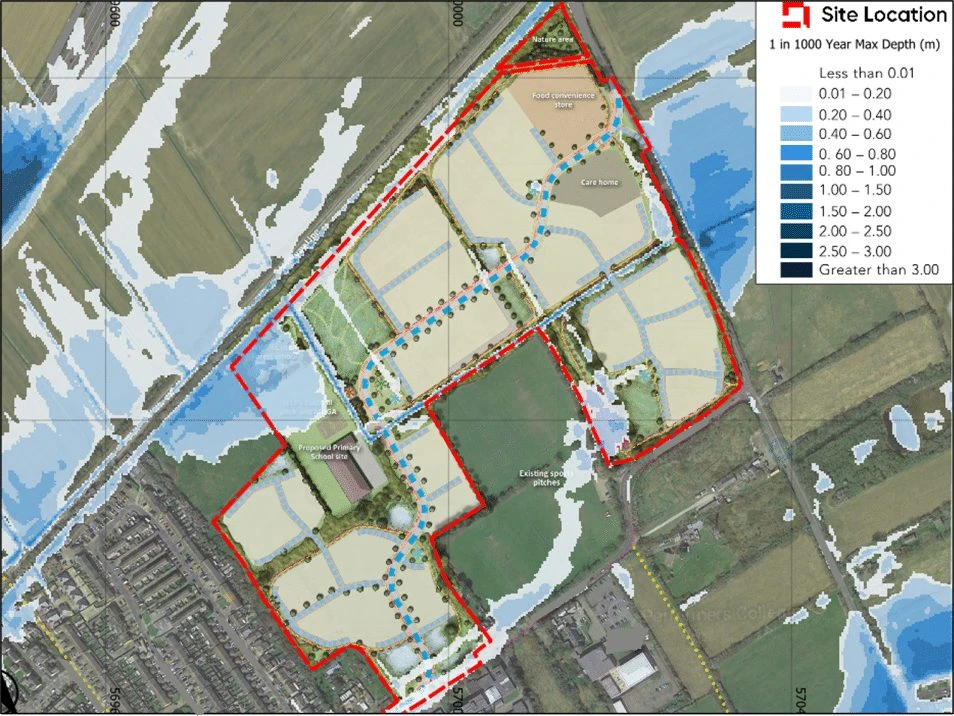
Figure 1. The proposed masterplan overlaid with modelled maximum flood depths for the 1 in 1000 year event. Development parcels sit outside the modelled extent, with lower-lying land retained for open space, sports pitches and nature areas. (Site labels and grid references redacted.)
-
National Infrastructure Resilience: I’ve supported major utility providers by delivering FRA and Drainage Strategies for over 50 sites including wastewater treatment works, pump station infrastructure, telecommunications installations, and critical electricity substations. Wastewater treatment works are often close to rivers and at risk of fluvial flooding. Flooding of these assets can have serious consequences. My work reduces the risk of objection at planning stage, and the operational risk for asset owners and managers. The same applies to electricity substations, where one flood can leave thousands of people without power. Flood risk matters for new substation works and for reviews of existing substation portfolios.
-
Renewable Energy (Solar Farms): I act as the lead contact for renewable energy developers, creating bespoke mitigation strategies that manage runoff from solar arrays while promoting environmental enhancement. I’ve overseen detailed hydrology and 1D-2D hydraulic modelling for the FRA supporting a Nationally Significant Infrastructure Project (NSIP) Development Consent Order (DCO) solar farm application, within a complex, low-lying, pumped catchment. Breach modelling was also required to demonstrate to the EA that a credible maximum worst case scenario had been considered in the design of the scheme including vulnerable assets such as the Battery Energy Storage System (BESS) and transformers.
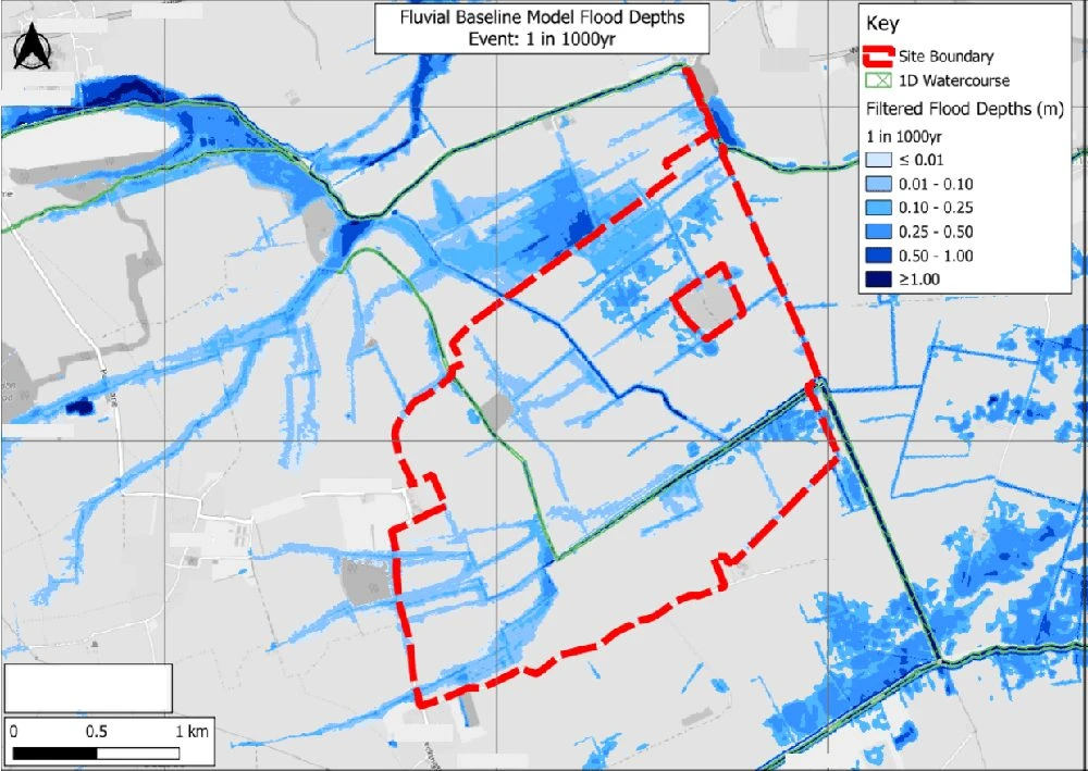
Figure 2. Baseline fluvial hydraulic model output for the 1 in 1000 year event. Modelled flood depths across the site and wider catchment, with the 1D watercourse network shown in green and the site boundary in red. (Place names and grid references redacted.)
-
Flagship Community Projects: I have spearheaded the flood and drainage strategy works for several lottery-funded schemes under the National Lottery Heritage Fund. These have included park and community space redevelopments in Hertfordshire, which involved re-aligning riverbanks, replacing footbridges (East Herts 3/25/2005/FUL), weir removals, and in-channel habitat creation. Others have been joint projects with Local Planning Authorities and the Royal Society for the Protection of Birds (RSPB), improving wetland sites in the south of England. The works changed water level control structures to hold more water during key breeding seasons, improving the wetlands for birds.
-
Retrospective Pond Developments: I have supported several clients in retrospective applications, or enforcement appeals, for constructed ponds/ water bodies built without permission. In each case, I have overseen detailed hydraulic modelling and calculations to verify that the development as constructed has not increased flood risk offsite - and in many cases actually reduced downstream risk. One of which was an enforcement appeal - which the Inspector allowed following our case submission.
A bit about me
Having grown up in Bristol, then lived in Sussex for 6 years, I’m now back west, in Worcester. My time in Sussex diluted my dulcet West Country accent, which people tell me is probably for the best! When I’m not unlocking tricky development sites, much of my time is now taken up being a Dad to my daughter - who does share a name with a river in the UK, just a coincidence though! I’m sure she’ll be writing FRAs in no time!
Also, I have two very ‘enthusiastic’ dogs. They’ve been known to “remodel” a sofa or two in the past, but I’m hopeful those days are behind us!
Articles by Nick
Flood Risk Assessment and Pluvial Hydraulic Modelling for Residential Development in Essex
Read moreSurface Water Flood Map Challenge Supporting Residential Development in Woking
Read moreSurface Water Drainage Strategy and Flood Risk Assessment for Brownfield Commercial Redevelopment
Read moreSite-Specific Hydraulic Modelling Supporting Permission in Principle in Uttlesford, Essex
Read moreAppeal Allowed for Retrospective Pond Development
Read morePermission Secured After Successful Appeal in Petersfield
Read moreWork with us
Talk to us about your site.
Tell us where your site is and what you’re planning. We’ll explain what’s needed and send a free, no-obligation quote.