Through detailed TUFLOW hydraulic modelling informed by updated site conditions and topographic survey data, Aegaea demonstrated that the site should instead be treated as Flood Zone 1. Following review of the modelling and supporting technical evidence, the Environment Agency withdrew its objection and Permission in Principle was approved shortly afterwards.
The Challenge
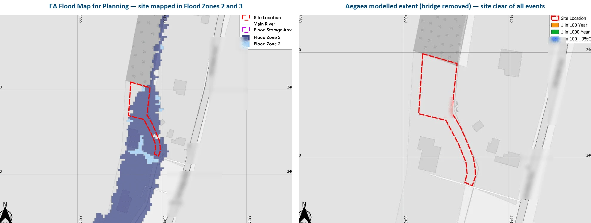
The site comprised a small residential plot on the edge of a settlement in Uttlesford, Essex, brought forward through a Permission in Principle application for a single dwelling. The Environment Agency’s Flood Map for Planning showed the site as lying predominantly within Flood Zone 3, with part of the frontage falling within Flood Zone 2.
The published flood extent was influenced by a dilapidated bridge located on an adjacent ordinary watercourse downstream of the site. Historically, the structure had restricted flow within the channel and caused water to back up across the surrounding floodplain. However, the bridge had been removed prior to the planning application, and the Flood Map for Planning had not yet reflected the updated site conditions.
Based on the mapped Flood Zone designation alone, the proposal faced significant planning constraints. Residential development within Flood Zone 3 would ordinarily trigger the Sequential and Exception Tests under the National Planning Policy Framework (NPPF), and the local planning authority was not minded to support the Permission in Principle application without further technical evidence.
The key challenge was therefore to determine whether the published flood mapping still accurately reflected the current flood risk at the site following removal of the downstream bridge structure. To progress the application, site-specific hydraulic modelling was required to demonstrate how the watercourse now behaved and whether the proposed dwelling plot itself remained at risk of flooding.
Aegaea’s Approach: Site-Specific Hydraulic Modelling Approach
Aegaea reviewed the hydraulic modelling outputs that informed the Environment Agency’s Flood Map for Planning and identified that the existing model was based on a 2D-only representation of the floodplain. The model did not contain 1D channel or bridge structure elements and therefore could not accurately represent the hydraulic influence of the historic bridge or be updated to reflect its removal.
To assess the current flood risk conditions, Aegaea developed a new site-specific 1D-2D coupled hydraulic model in TUFLOW using a fresh topographic survey of the site and adjacent watercourse corridor. The watercourse channel and structures were represented within the 1D domain and dynamically coupled to the surrounding floodplain in 2D, allowing the hydraulic influence of the bridge structure to be modelled explicitly.
Two scenarios were tested: a historic scenario with the bridge in place and a present-day scenario with the bridge removed. Each scenario was modelled for the 1 in 30 year, 1 in 100 year and 1 in 1000 year flood events, including appropriate climate change allowances in accordance with current Environment Agency guidance.
The modelling demonstrated that, with the bridge removed, flood extents no longer affected the application site during any of the modelled events up to and including the 1 in 100 year plus climate change and 1 in 1000 year scenarios. Based on the technical definition set out within national planning policy and Environment Agency guidance, the site therefore functioned as Flood Zone 1.
Aegaea prepared a Flood Risk Assessment, hydraulic modelling report and supporting model files documenting the methodology, topographic inputs, hydraulic assumptions and comparison against the published Flood Map for Planning.
The Outcome
Following review of the hydraulic model files and supporting Flood Risk Assessment, the Environment Agency confirmed in writing that, with the bridge removed, the site should be treated as Flood Zone 1 and formally withdrew its objection to the application.
Six days later, the local planning authority resolved to grant Permission in Principle for the proposed dwelling.
This project demonstrates how site-specific hydraulic modelling can refine the published understanding of flood risk where national flood mapping does not reflect current site conditions. By developing a robust 1D-2D hydraulic model representing the updated watercourse configuration, Aegaea provided the technical evidence required to support a proportionate, evidence-based planning decision and unlock development on a constrained residential site.