The proposals initially lay partly within SEPA‘s surface water and small watercourse flood mapping and required the diversion of an existing drainage ditch – a combination that had attracted a holding objection from SEPA prior to Aegaea’s involvement.
Through detailed flood modelling of baseline conditions, the proposed realigned channel, and the resulting flood levels, Aegaea demonstrated that the scheme would not increase flood risk elsewhere and could be made safe and operational throughout its design life, both of which are critical requirements of NPF4 Policy 22, and North Lanarkshire’s Supplementary Planning Guidance documentation SPH09 – which states that new development should not be at risk of flooding, materially increase the probability of flooding elsewhere, or increase areas of land which require protection by flood prevention measures.
Policies DSP2 (B) and DSP4 of the North Lanarkshire Local Plan (2022) were also adhered to – which state that new developments must protect and enhance the physical characteristics of watercourses throughout the region
SEPA subsequently removed its holding objection, and the watercourse diversion was consented under a EASR licence, with North Lanarkshire Council granting full planning permission.
The Challenge
The site is operated by DataVita, whose Chapelhall operations now sit at the heart of one of the UK’s most significant digital infrastructure investments with North Lanarkshire having been named, in partnership with AI firm CoreWeave, as the UK Government’s latest AI Growth Zone.
Aegaea was commissioned to support a Section 42 application for a revised, reduced-scale expansion of the facility, including an extension to the existing building, a rearranged service yard and associated plant, and updated drainage arrangements.
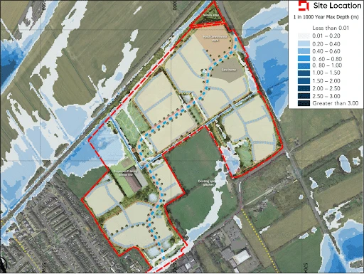
SEPA’s flood mapping showed that, while the site sits outside any modelled fluvial flood extents, parts of it fall within the medium and high likelihood surface water flood extents (i.e. up to the annual probability of flooding up to the 1 in 100 year baseline storm event).
In accordance with NPF4, sites located close to or within the 1 in 200 year (plus climate change) storm event (from any source) should be subject to a Flood Risk Assessment.
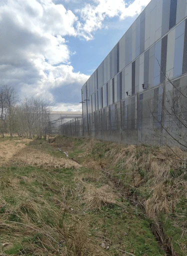
Following a site visit and review of the available mapping and topography, these extents were attributed to a combination of runoff from higher ground to the east and an existing open drainage ditch running along the eastern boundary of the site. The baseline surface water flood risk was therefore assessed as medium-to-high.
The proposals also required the existing ditch to be diverted and realigned to provide biodiversity and amenity benefits, as well as flood risk resilience. This introduced two linked planning challenges. First, the development is classified as Essential Infrastructure under NPF4 Policy 22, meaning it must be demonstrably safe and operational during flood events. Second, any alteration to the watercourse and its culverted outfall could not be allowed to increase flood risk downstream.
SEPA issued a holding objection, requiring suitable culvert blockage scenarios to be tested, a comparison against existing conditions, and finished floor levels set safely above the design flood level including an allowance for blockage.
Aegaea’s Approach: Site-Specific Hydraulic Modelling
To resolve SEPA’s objection, Aegaea developed a site-specific 2D hydraulic flood model representing the drainage ditch, its structures and the surrounding ground, and used it to inform the design at three key stages.
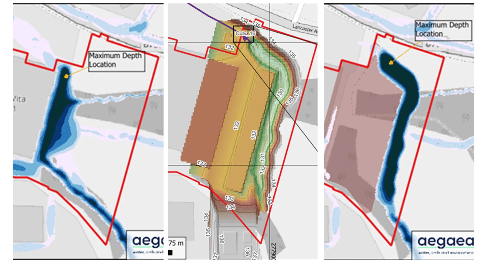
- Establishing baseline conditions. Aegaea built a baseline flood model of the existing, pre-development site. This characterised how surface water currently behaves across the site — confirming that the published flood extents are driven by runoff from the higher ground to the east interacting with the existing ditch and its culverted outfall.
- Testing the proposed realigned channel. The proposed diversion, designed by Woolgar Hunter Engineers, replaces the existing ditch with a new 155m open channel — retaining a comparable length of open watercourse — with a 1.5m base, graded side slopes, and a new headwall replicating the existing culvert inlet dimensions, controlled by an orifice plate at a new manhole. Aegaea modelled this proposed configuration for the critical 1 in 200 year plus climate change event across a range of storm durations. To meet SEPA’s requirements, culvert blockage scenarios of 25% and 50% were also tested and compared against equivalent blockage scenarios for the existing culvert. Comparing the design and baseline models confirmed betterment downstream — a general reduction in peak flood depths — with no increase in risk elsewhere.
- Informing finished floor levels. The modelling defined a peak water level of 132.13m AOD for the 1 in 200 year plus climate change event including a 25% blockage. On this basis, Aegaea recommended raising the finished floor level of the eastern extension by 0.15m so that it sits safely above the design flood level. Recognising the operational realities of an Essential Infrastructure site — where heavy plant and generators require level, accessible enclosures that would not be entered during a severe weather warning — Aegaea presented the modelled evidence to justify a proportionate 150mm freeboard for the plant enclosures, while keeping the development safe and operational in line with Policy 22.
The findings were documented in a hydraulic modelling report (including completion of the required SEPA’s FRA Checklist) and a supporting Flood Risk Assessment, setting out the methodology, topographic inputs, blockage assumptions and the pre- versus post-development comparison.
The Outcome
Following review of the hydraulic modelling and the supporting Flood Risk Assessment, SEPA was satisfied that:
- all risks of flooding are understood and addressed;
- there is no reduction in floodplain capacity, increased risk for others, or a need for future flood protection schemes;
- the development remains safe and operational during floods;
- flood resistant and resilient materials and construction methods are used; and
- future adaptations can be made to accommodate the effects of climate change.
complying fully with Policy 22 of NPF4.
SEPA removed its holding objection, and the diversion of the watercourse was consented under a EASR (formally CAR) licence.
North Lanarkshire Council subsequently granted full planning permission for the expansion of the data centre.
This project demonstrates how site-specific hydraulic flood modelling can unlock the expansion of nationally important infrastructure on a constrained site. Aegaea provided the evidence SEPA needed to discharge its objection — and gave the design team the key information required for setting finished floor levels and freeboard around the operational needs of a live data centre. Our expert flood risk consultants, drainage engineers and flood modellers combined to provide a successful planning application outcome.
As North Lanarkshire positions itself as one of the world’s most advanced AI sites, Aegaea are proud to have supported this development, and continues our trend as being at the front line of innovation throughout the UK.