
I joined the flood risk sector in 2023 after completing my degree at the University of Salford, where I specialized in rivers and natural flood management. This career path is a personal passion for me; growing up in a high-risk flood area in West Yorkshire, I’ve seen the consequences of flooding firsthand. Today, I use that perspective to help clients navigate the “puzzles” of their own sites. Whether I’m building complex hydraulic models or designing natural flood management schemes, my goal is to provide the technical clarity needed to move projects forward safely and successfully.
How I can help you
- Precision Hydraulic Modelling: I build detailed 1D and 2D models using TUFLOW and Flood Modeller to accurately map risks that national maps might miss.
- Natural Flood Management (NFM): I specialize in river restoration and NFM schemes, using modelling to prove that slowing the flow with log jams and re-meandering protects the wider catchment.
- Correcting Inaccurate Flood Maps: If you believe the official Environment Agency maps don’t reflect the reality of your plot, I use micro-topographical modelling to provide a more precise, often more favourable, view.
- Wetland creations and flow path diversions: I build detailed models to capture current flow paths and then potential designs to create wetland and multi use environments and divert surface water pathways within sites to unlock the potential they have.
Expertise in action
-
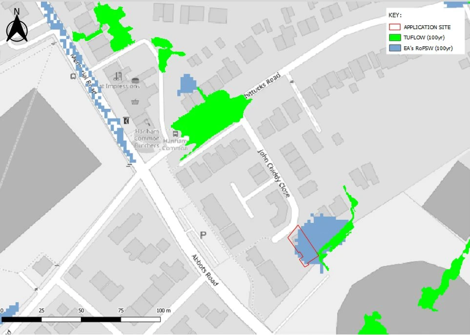
Unlocking Property Sales: I constructed a high-resolution 2D TUFLOW model to assess the surface water flow paths for an urban residential site. Urban sites are often miss represented in larger models as micro topographical features are not captured but can have a big impact on the surface water flow paths in the area. The homeowner came to us unable to sell their house due to EA surface water classifications. Within the model I used the planning portal and google street view to investigate the area and was able to find the surface water drainage plans associated with the development the site sat on and also identify key micro-features like kerbs and walls which redirect flow routes, especially smaller surface water ones. This allowed the realistic flow paths to be demonstrated and show the site was not at risk, allowing the sale to proceed.
-
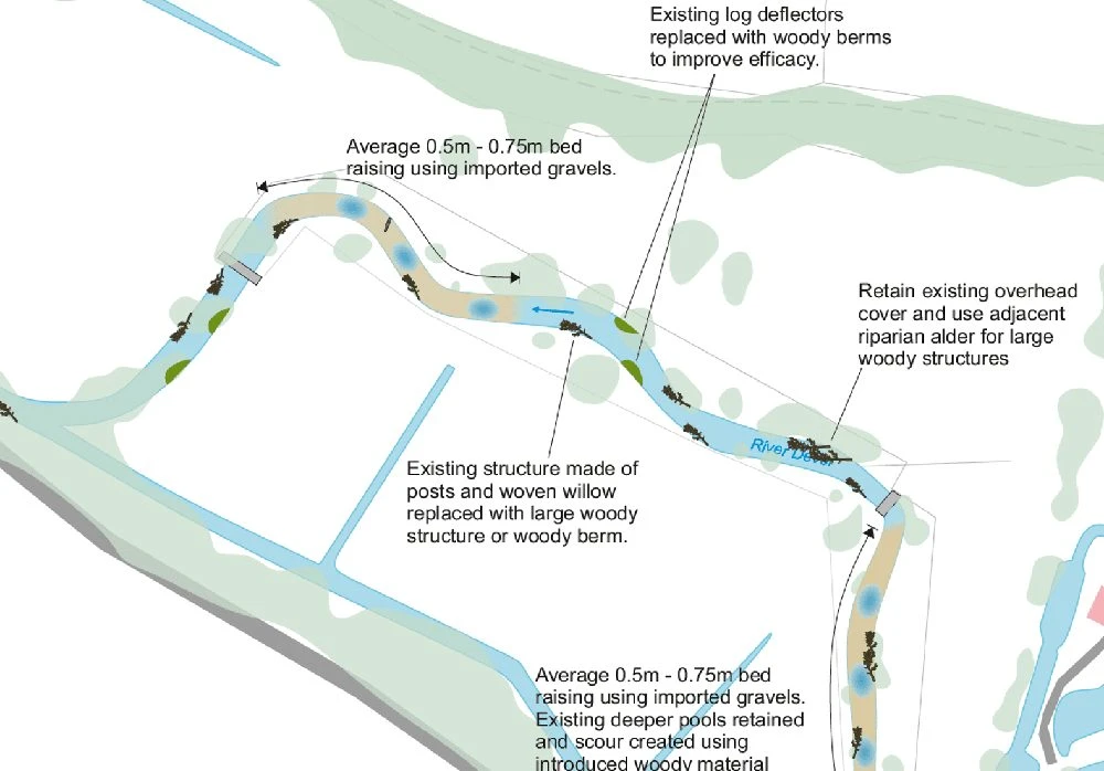
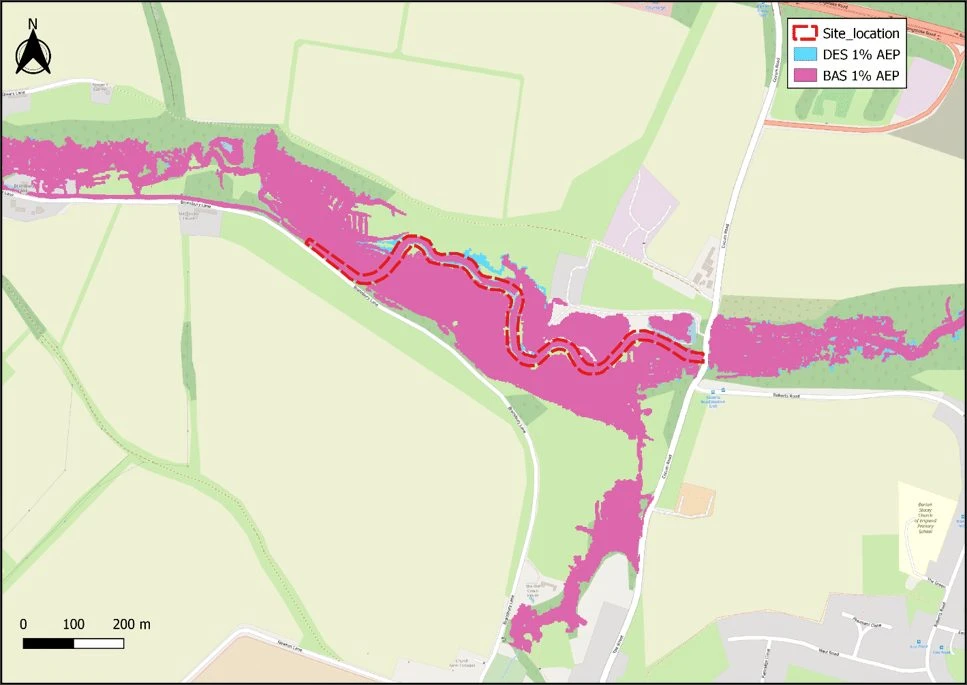
River Restoration: I developed a 1D-2D linked model to support a planning application for river re-meandering and Natural Flood Management (NFM) to increase the biodiversity in the area. Several NFM components were proposed as part of this project including bed raising to create a riffle-pool sequence, woody berms and log deflectors which allows a more natural flow dynamic along the river reach and results in more habitat creation. This was modelled by updating cross sections in line with the proposed bed levels and altering the widths inline with the woody berms. Another way this was modelled was increasing roughness and adding blockages to replicate the woody berms and log deflectors. My work demonstrated that the restoration safely managed water without increasing risk to neighbouring land only marginally changing the overall flood extents, leading to successful approval.
-
Site Feasibility Study: I was the lead modeller on a job looking into the feasibility of a site with development from an existing commercial site to a residential site. The site is within a heavily urbanised area with 2 constrained rivers. The EA mapping showed the site was located within Flood Zone 3 however we had photographic evidence of the site not flooding within a recent flood event. The EA held a model which was reviewed and found to be unsuitable for this assessment, therefore communication with the client lead us to creating a new 1D-2D linked model to get the best representation of the site. At this masterplanning stage multiple options for the site were tested to alleviate the flooding with aims to unlock developable areas on the site.
-
Wetland Creation: I created a 2D model to support a multidisciplinary planning application for the creation of a wetland to support the agricultural multi use area in which I had to coordinate communication with the client and other teams including landscape architects and ecologist to understand the on site flow pathways so a design could be created to enhance the natural benefits of the area and allow more water storage on site helping reduce the risk of flooding downstream and allow the site to thrive. A baseline model was built to inform the designers of the current flow pathways that was then used to create a design which was included within the model using a topographical surface with contours and additional topographical modifications to connect the wetland features. Once the final designs had been agreed a final stage of modelling was commissioned which was breach modelling to demonstrate the worst case scenario to the planning authority.
-
NFM Consultancy: I have contributed to notable natural flood management projects, including consultancy for log dams in partnership with the Environment Agency where we were tracking the flow within the upper reaches of the catchment to understand how the log jams were altering the flow within the area and to understand the catchment to find the ideal location for more to help mitigate storm flows in a flashy upper catchment. I have also worked on other restoration projects for both rivers and agricultural land with partners like Wessex Rivers Trust and Wiltshire Wildlife Trust to find solutions that benefit all parties.
A bit about me
I love the complex challenges that flood modelling brings as an avid chess player problem solving is my cup of tea. When I’m not working you’ll usually find me busy wrangling animals that think escaping is a full time job, as I live on a working farm, or with my nose in a good book.
Work with us
Talk to us about your site.
Tell us where your site is and what you’re planning. We’ll explain what’s needed and send a free, no-obligation quote.