Updates to Climate Change Allowances – Rivers Peak Flow
**Please note that the climate change allowances have been updated as of 20th of July 2021**
Please refer to this updated post to look at the new guidance.
In accordance with the National Planning Policy Framework , February 2019, there is a requirement for development in Flood Zones 2 and 3 to consider climate change scenarios. The Environment Agency until February 2016 applied a 20% blanket policy across the whole of England, the practice has now been superseded and replaced with a River Basin Districts approach whilst also applying the findings of the UK climate change projections 2009 for differing future scenarios to assess the impacts of climate change. In addition to this the type of development also dictates the climate change allowances applied and the flood zone with reference to the EA flood map for planning.
For example, in the South East of England 20% was previously applied for climate change for all development. If though, you wanted to build a residential dwelling, you would have to review a new allowance of 45% and 105%.
It can be seen from this example the impact the new approach to climate change has had on assessing flood risk across the country to future development. The increases in the climate change can increase flood depths, flood extents and sometimes both. It is therefore important before proceeding with any development to assess the impact climate change could have on your development/asset.
River Basin Districts
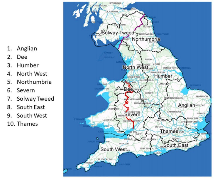
The EA have now divided England into 10 river basin districts. River Basin Districts means the area of land and sea, made up of one or more neighbouring river basins together with their associated groundwaters and coastal waters (identified under Article 3(1) of Directive 2000/60/EC as the main unit for management of river basins). Of the basins that exist in England these are set out below;

Climate Change and its impact on Planning and Development
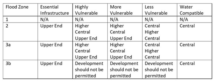
As mentioned the new climate change approach ties river basins, climate change allowances, flood zone (reference to Table 1 of the NPPF/PPG) and the vulnerability of a development (reference to Table 2 of the NPPF/PPG) to define the climate change peak river flows.
The allowances to each river basin, flood zone and vulnerability are defined by percentiles.
-
central allowance is based on the 50th percentile
-
higher central allowance is based on the 70th percentile
-
upper end allowance is based on the 90th percentile
To simplify the approach now being implemented we have provided tables below to understand which allowance is applied to each type of development and flood zone in England.

Each application therefore must be viewed individually; no application is the same. A Flood Risk Assessment iterates this sentiment, and each assessment is therefore unique especially the approach and methods applied to each development.
Each assessment is different due to multiple factors which can include environmental conditions, flood zone, type of development, and policy to name several
How can we help you?
Our team at Aegaea have supported hundreds of developments across London and as such have a diverse knowledge base that can support you and your development.
The team can draw reference to previous projects whilst also advising on the peak river flow allowances specific to your river basin. We welcome the opportunity to work with you. Should you have a project or submitting a planning application and you are unsure if a Flood Risk Assessment is required, contact of one our team and we will be happy to talk through whether an assessment is required.
Request your free, expert quote now
Aegaea work alongside home owners, private developers, planning consultants, architects, local authorities, international development agencies and contractors. Aegaea know exactly how to help you.