What are the updates to Climate Change Allowances in England, 20th July 2021
As of the 20th of July 2021, the Environment Agency have published revisions of their climate change guidance for application to river flows. These were previously updated in 2016.
What was the climate change guidance before the update?
Prior to the amendment, climate change for rivers was undertaken on a regional basis (Thames, South East, South West etc) for which there were 10. Within each of those broad areas, central, higher central, upper and H++ scenarios were defined along with the development horizons.
What has the climate change guidance changed to?
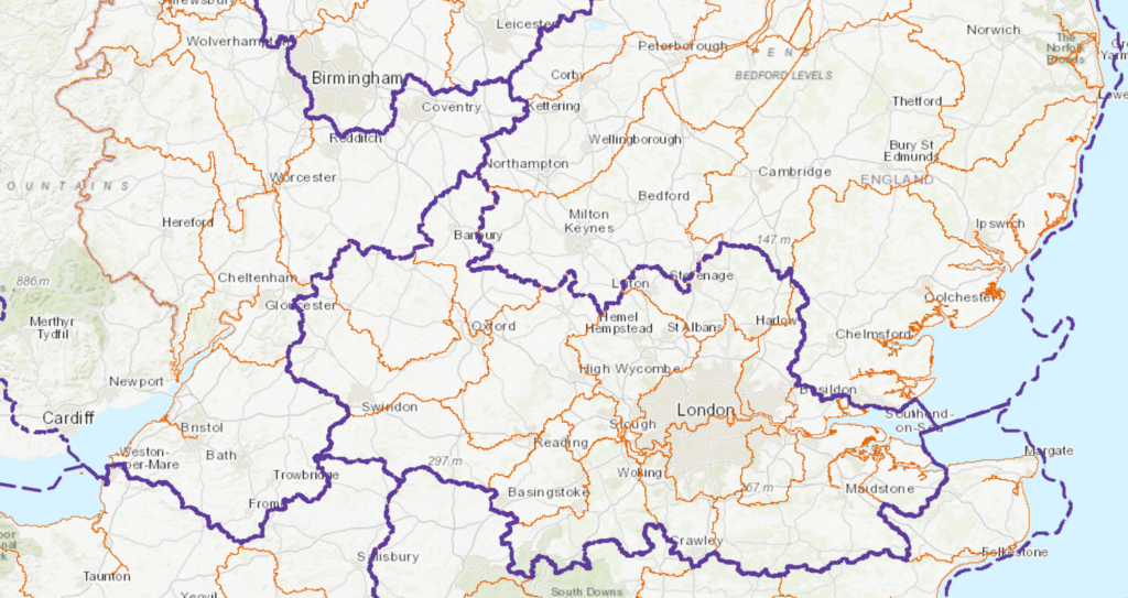
The revision of the guidance now defines a “management catchment boundary” within each region. Each of these management catchment boundaries has specific climate change allowances within it and they can vary significantly between units of the same region. For example, the old Humber region now contains 15 sub catchments, while the Thames region contains 17!

*River Basin Regions – Purple, Management Catchment Boundaries – Orange
The management catchment boundaries are based on the surface water management catchment boundaries from the Water Framework Directive. You can view these using the catchment data explorer here.
Who does this change affect?
Peak flow allowances for climate change will affect all modelling and mapping studies, FRAs and developments in England from July 20th 2021. That means that if you are currently in an application process, or about to begin one, you will need to take into account the new guidance. This might be particularly important if you are planning for safe access and egress, or conducting site due diligence.
Have the climate change factors all increased?
No. Climate change increase is not uniform across the country. In fact in quite a number of regions the climate change allowances have reduced. As a result, sites that have previously been rejected on the basis of not being viable due to climate change may now be able to be brought forward successfully. Please get in contact if you would like to discuss any specifics relating to this.
Where can I find the updated guidance?
The updated guidance changes can be found here and the map is here. We have also attached a tabular version below for your convenience, courtesy of the EA.
Peak_river_flow_climate_change_allowances_by_management_catchment
Aegaea have also compared all the changes to the old guidance and you can find a handy table to show changes here showing all the changes for all the epochs.
How can Aegaea help?
Here at Aegaea we have gone through the latest changes and the impacts in each area. We think there is significant opportunity to look at the impacts of the change in guidance and we’d welcome anyone to get in touch with us to review the potential impacts on your sites.
We’ll be putting together a more comprehensive assessment of the changes in due course, so watch this space!
Request your free, expert quote now
Aegaea work alongside home owners, private developers, planning consultants, architects, local authorities, international development agencies and contractors. Aegaea know exactly how to help you.