

I graduated with a First Class degree in Geography from the University of the West of England (UWE) in 2024. My passion for hydrology started during my studies, where my favourite modules and my dissertation focused on the complex relationship between catchment characteristics, historic climate change, and river behaviour. Now, as a Flood Risk Consultant at Aegaea, I’m putting that passion into practice by helping clients navigate the technical requirements of planning applications and flood safety.
How I can help you
- Policy-Compliant Assessments: I prepare Flood Risk Assessments (FRAs) that meet the strict requirements of national and local planning policies.
- Flood Evacuation Planning: I design practical Flood Risk Evacuation Plans (FREPs) to ensure site users have clear, safe routes during extreme weather events.
- Data Analysis & GIS: I use Geographic Information Systems (GIS) to analyse topographical data and flood mapping, ensuring that the risk to your site is accurately represented.
- Surface Water Strategies: I am expanding my knowledge in Surface Water Drainage Strategies, using tools like InfoDrainage and AutoCAD to support minor development extensions up to multiple residential dwelling schemes.
Expertise in action
-
Large-Scale Residential Planning (Corringham): I supported an outline application for over 400 dwellings and a primary school. By analysing site-specific modelling, I was able to evidence that national-scale data was overestimating flood risk and therefore a more detailed site specific model was required. The detailed model provided much more accurate representation of the flood extents required to assess a planning application, the design flood event. This information was then used to evolve the masterplan to make the scheme more policy compliant and greater success of being approved once submitted.
-
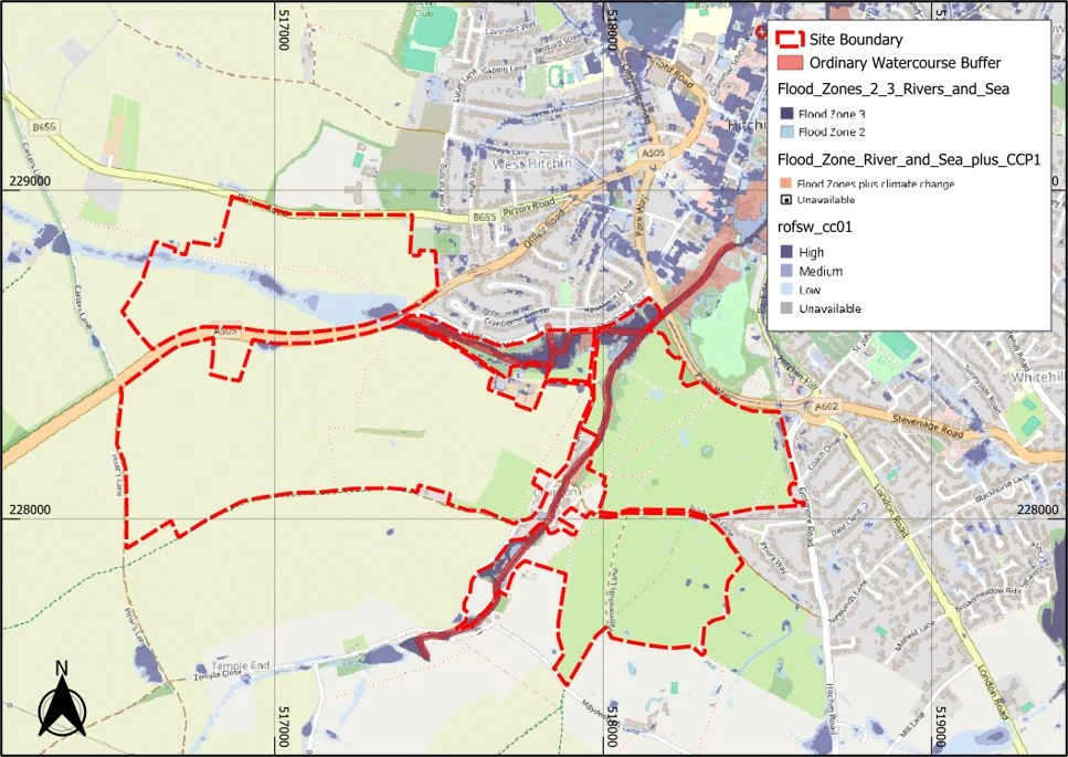
Flood Risk Knowledge to Inform Development Potential and Masterplanning (Hitchin): I prepared a Flood Risk Appraisal providing the findings of a due diligence investigation, carried out to provide advice relating to the flood risk requirements and constraints alongside other colleagues involved in other professions, to inform development and masterplanning. The site included approximately 145 hectares over 4 no. land parcels with the proposals being the construction of major housing-led mixed-use development with an indicative capacity of 1,800-2,200 planned units over three neighbourhoods, local centre, school and parks. The project involved collaborating all policy requirements and flood sources (i.e. Flood Zones, the Sequential Approach, Watercourse Buffer Zones, Permits and Crossings) to outline all possible developable areas and constraints that could be highlighted later in the project and how these could be overcome.
-
Minor Development - Extension, Residential Dwelling, (Kensington and Chelsea): Produced a Flood Risk Assessment for an extension on a residential dwelling to provide greater habitable space. The site post extension had limited external space to accommodate SuDS, I proposed a green roof solution in line with the SuDS drainage hierarchy to manage surface water effectively in a dense urban environment.
-
Telecommunications Infrastructure (Arun): I prepared an FRA for a new mast installation. I conducted analysis into topographical levels to derive a safe, raised platform design that protected the equipment.
-
Residential Guidance (Surrey): I consulted with a homeowner whose property was situated in a high-risk flood zone. By recommending a design that matched existing floor levels while incorporating voids for water flow, I provided a technical path forward that minimized the risk of planning objections.
A bit about me
Outside of work, I stay very active! You can usually find me in the gym, out for a run, or in the pool. I also spend a lot of time in the Dojang, where I practice Tae Kwon-Do.
Work with us
Talk to us about your site.
Tell us where your site is and what you’re planning. We’ll explain what’s needed and send a free, no-obligation quote.