What this means for your site
If you only read one section, read this one.
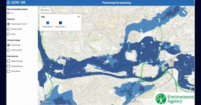
- Your site is in Flood Zone 1, over a hectare, or shown on the Environment Agency Flood Map as at risk from any source. You now need a flood risk assessment. This is particularly prudent for sites shown to be at risk of surface water, “don’t get caught out”. You can check if your site is at risk by using the Environment Agency flood mapping and Check Your Long-Term Flood Risk. For further guidance see below with reference to Policy F4.
- Your scheme could affect drainage on or around the site. You now need a SuDS statement or more commonly known as a Surface Water Drainage Strategy showing how the National Standards have been met, whatever the size of the scheme. This used to apply to major development only.
- You are promoting a data centre, EV charging hub, heat network, hydrogen facility or carbon capture project. You are now classed as essential infrastructure, which opens up locations in Flood Zone 3 that were previously More challenging to gain approvals.
- You have an application awaiting determination in England. It is being decided against the new Framework from today. There is no grace period.
Does the new NPPF apply to my application now?
Yes. Annex A, paragraph 1 is unambiguous: the policies are material considerations that must be taken into account in decision-making from the day of publication. There is no transitional period and no carve-out for applications already in the system, so an application awaiting determination in England today is being decided against the August 2026 Framework.
Plan-making is different: Annex A paragraph 7 sets 17 August 2026 as the start date only for the plans identified in paragraphs 4 to 6, with everything else continuing under the December 2024 Framework and its transitional arrangements.
Existing local plan policies keep their weight unless they are materially inconsistent with the Framework’s national decision-making policies, in which case the offending policy carries very limited weight. Age alone does not reduce weight. For flood risk this cuts both ways: a local policy applying the sequential test more broadly than Policy F5 may now be inconsistent, while one requiring SuDS to the National Standards is reinforced by F8.
How is the Framework structured, and where did the old paragraphs go?
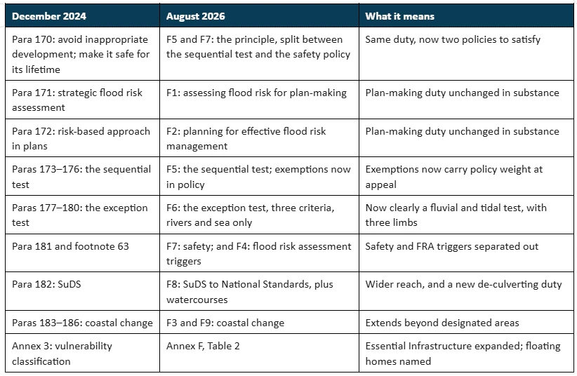
The 2026 Framework runs to 20 chapters against the previous 17, and every policy now carries a code. Flood risk sits in Chapter 18, “Managing flood risk and coastal change”, at pages 83 to 87. Policies F1 to F3 are plan-making policies, and F4 to F9 are national decision-making policies. Annex F carries the technical tables at pages 124 to 128. The old Chapter 14 has been split three ways: climate change is now Chapter 5 (CC1–CC3), water infrastructure sits in Chapter 10 (W1–W4), and flood risk and coastal change is Chapter 18 (F1–F9).
Two structural points matter. First, climate change and flooding are now separated. Second, the annexes are policy: Introduction paragraph 9 states that they are national planning policy, so the tables in Annex F are not guidance.
Renumbering sounds cosmetic, but it is not if you have live documents in the system. A flood risk assessment or committee report citing the December 2024 paragraph numbers is not wrong in substance, but it cites a document that is no longer national policy, and case officers will be working from the F codes.
When do I need a flood risk assessment?
Policy F4 sets the triggers, and it is the right starting point, because an assessment can be required even where the sequential and exception tests do not apply. A site-specific flood risk assessment should accompany all proposals in Flood Zones 2, 3a and 3b. In Flood Zone 1 it is still required for sites of one hectare or more, land the Environment Agency has identified as having critical drainage problems, and land identified in a strategic flood risk assessment or the Flood Map for Planning as being at risk of flooding from any source, now or in the future.
That last trigger is broad, and it reaches surface water. A Flood Zone 1 site with a surface water flow path on the mapping can need an assessment even though it sits outside the river and sea flood zones. Because the mapping keeps moving (the Flood Map for Planning has taken the NaFRA2 data and gained surface water and climate change layers over the past year), a site screened against an older version may need re-screening before an application goes in.
Two points of interpretation are worth flagging. First, F4(2) uses “and” between its three Flood Zone 1 triggers, which literally would make them cumulative. The consultation draft used “or”, and the connector changed when two triggers were merged, which points to a drafting slip, not a deliberate choice. We read them as alternatives, so any one triggers an assessment, and we expect this to be argued until clarified. Second, “at risk” is itself undefined. The policy does not say whether a site must be completely dry, safe below a hazard threshold, or safe up to a particular design event such as the 1 in 1,000 year plus climate change extent, so expect inconsistent application on marginal sites.
Has the sequential test changed?
The sequential test itself has not changed. What has changed is where the rules live, and how often the test is reached at all. Policy F5(1) states the aim and caps the area of search:
The aim of the sequential test is to steer new development to areas with the lowest risk of flooding from any source. Where the test applies, development proposals should not be located in areas at risk of flooding where alternative sites, appropriate for the development, are reasonably available in areas with a lower risk of flooding. The area to which the test is applied should not be greater than the anticipated catchment of the development in terms of its likely occupiers or users.
The aim reaches every source of flooding, not just rivers and the sea: surface water, groundwater, sewers and reservoirs are all in scope. The catchment cap is self-scaling, so a strategic scheme with a wide occupier draw gets a wide area of search, and a fifteen-unit scheme a narrow one. Its effect is therefore greatest where the area of search was already small.
One change of verb is worth watching. The December 2024 Framework said development “should not be allocated or permitted” where reasonably available lower-risk sites existed. F5(1) now says proposals “should not be located” there. On one reading it is tidying, needed because plan-making and decision-making are now separated. On another, the policy no longer tells a decision-maker to refuse, a softening at the very point where everything around it has tightened. We expect it to be argued at appeal.
Does a fluvial or tidal site have any route out of the sequential test?
Yes, and this is the most useful thing in the chapter. It is also widely misreported, with several commentaries describing F5(2)(b) as a surface water exemption and stopping there. There are two routes out:
i. No built development within the site boundary, including access or escape routes, land raising or other potentially vulnerable elements, would be located on an area that would be at risk of flooding from any source, now and in the future …; or
ii. Where the site would be at risk of surface water flooding only, the proposed layout, design, and mitigation measures would ensure that occupiers and users would remain safe from current and future surface water flood risk for the lifetime of the development without increasing flood risk elsewhere in accordance with policy F7.
The first is an avoidance route, and it covers every source of flooding. It asks whether the scheme can be laid out so that nothing at risk sits in the at-risk area, including access, escape routes and land raising. A fluvial site designed around its flood extent is out of the test.
The second is a mitigation route, and it covers surface water only. The site must be at risk of surface water alone, so a site with both fluvial and surface water risk cannot use it, and it imports Policy F7’s safety standard by reference.
In short, a fluvial or tidal site can avoid a sequential test through a sequential approach on site, but it cannot mitigate its way out. A surface water site can do both. Anyone telling a fluvial client they have no route out has read only half the policy.
The de-minimis exemptions. Policy F5(2)(c) writes three long-standing guidance exemptions into the Framework: householder development, small non-residential extensions under 250m², and changes of use (except changes of use to caravan, camping, chalet, mobile home or park home sites, which remain subject to the test). None is new in substance; what is new is that they are policy rather than guidance. Allocated sites are also exempt where the test was applied at plan preparation under F5(2)(a), and F5(3) confirms that the strategic flood risk assessment and the Flood Map for Planning provide the evidential basis.
Together, the two assessment routes, the catchment cap, the allocated-site exemption and the de-minimis list could materially reduce the number of application-stage sequential tests. That is the commercial headline for anyone promoting land.
A worked example: 15 homes in Flood Zone 1
This is an illustrative example of our own, not a case taken from the Framework. A landowner has a two-hectare field on the edge of a market town, in Flood Zone 1, with a surface water flow path running across one corner. The proposal is 15 dwellings.
Do you need a flood risk assessment? Yes, on two counts: the site is over one hectare (F4(2)(a)), and it is shown on the Flood Map as at risk from a source of flooding (F4(2)(c)).
Do you need to apply the sequential test? Not necessarily, and this is where the assessment earns its fee. If the layout can put all 15 plots, the access road and the escape route clear of the flow path, the avoidance route applies and the test falls away. If not, the mitigation route is still available, because the risk here is surface water only.
What if the same site were in Flood Zone 2? The mitigation route closes immediately, because the site would no longer be at surface water risk only. You are left with avoidance, and if the layout cannot achieve it, the sequential test applies in full and the exception test may follow.
The lesson is that the flood risk assessment is no longer just a supporting document. On this site it decides whether the sequential test applies at all.
Does the exception test still exist?
Yes, and its scope is worth reading carefully. Policy F6 is titled “Development in areas at risk of flooding from rivers or the sea”, and F6(1) applies to areas within flood zones 2, 3a or 3b. The exception test therefore engages on fluvial and tidal risk only. A site at risk from surface water alone never reaches it, however severe that risk.
F6(1)(a) requires refusal where the use is incompatible with the risk under Annex F Table 3. F6(1)(b) sets out the test itself, now expressed as three criteria : wider sustainability benefits that outweigh the flood risk; safety for the anticipated lifetime in accordance with policy F7; and no increase in flood risk elsewhere, with a reduction where possible. All three must be met, so failing any one means the test is not passed. The December 2024 version expressed this as two criteria, with safety and flood risk elsewhere combined. The second criterion does more work than it appears, because “in accordance with policy F7” imports a five-part refusal policy by reference.
F6(2) exempts allocated sites where the exception test was applied at plan-making stage, unless flood risk has increased significantly since, or the development has changed to introduce a more vulnerable use. “Significantly” is not defined, and some authorities may treat any increase as significant, so this is likely to be argued until it is tested. F6(2)(a) also disapplies the exception test wherever the sequential test is not required under F5.
Even where the exception test is not engaged, the flood risk assessment and sequential-test duties still apply, and surface water must still be assessed. The exception test being irrelevant tells you nothing about whether an assessment is needed.
What does Policy F7 require?
F7 is where the safety requirements live, and it is drafted as a refusal policy. Where development is proposed in a location known to be at risk from any form of flooding, now or in the future, F7(2) says it should be refused unless: the most vulnerable development sits in the areas of lowest flood risk, unless there are overriding reasons otherwise; it will be safe throughout its lifetime given how vulnerable its users are; residual risk can be safely managed, with safe access and escape as part of an agreed emergency plan; it is flood resistant and resilient enough to be brought back into use quickly after a flood without significant refurbishment; and flood risk will not be increased elsewhere.
SuDS, watercourses and de-culverting
Drainage gains more new policy than any other area of the chapter. Policy F8(1) expects any proposal that could affect drainage on or around the site to incorporate SuDS to control flow rates and reduce runoff volumes, proportionate to the scale of the scheme, with multifunctional water quality, biodiversity and amenity benefits where possible.
SuDS design now defers explicitly to national guidance. F8(2)(a) requires systems to be designed in accordance with the National Standards for Sustainable Drainage Systems, published in 2025. That is a compliance test, not a “have regard to”, fixing the National Standards as the design benchmark in policy. It also settles the delivery route: in England SuDS are secured through planning policy, not statute, because Schedule 3 of the Flood and Water Management Act 2010 remains uncommenced, and there is no SuDS Approval Body as in Wales. The Annex C information requirement, which like Annex F is national policy, is a statement setting out how the standards have been achieved.
What has changed, and what is genuinely new. Under the December 2024 Framework, SuDS were already required for any application that could affect drainage (paragraph 182), and specifically for development in flood-risk areas (paragraph 181c), so this was never a major-development-only duty. What was limited to major development was the trio in paragraph 182(a) to (c): taking Lead Local Flood Authority advice, meeting “appropriate minimum operational standards”, and having maintenance arrangements. F8 makes two distinct changes. It introduces, for the first time, an explicit duty to design in accordance with the National Standards (F8(2)(a)), which did not appear in the 2024 text at all; and it applies that duty, together with maintenance (F8(2)(b)), to any proposal that could affect drainage. Only the LLFA-advice requirement (F8(2)(c)) stays major-only. In practice that reaches almost every scheme, though a proposal that genuinely does not affect drainage, such as some changes of use, may fall outside it.
Policy F8(3) is entirely new, and it changes how watercourses are treated. Development should not enclose (culvert) an existing open watercourse unless there are compelling reasons to do so, and should where possible remove existing culverts and renaturalise river channels, subject to three exceptions: where doing so would increase flood risk, result in other environmental harm, or cause harm to heritage assets (the heritage-assets exception was added between the consultation draft and the final Framework). A national policy presumption against enclosing watercourses, together with a positive expectation to de-culvert and renaturalise, has not carried planning-policy status before. Expect it in drainage strategy design and in river-restoration and biodiversity cases.
Have the flood zones changed?
No, but their status has. The definitions are carried across unchanged, but Annex F now carries all three tables, being the flood zones, the vulnerability classification and the incompatibility matrix, and the annexes are policy. Previously the zone definitions and the incompatibility table sat in guidance.
Zone 3b matters most in practice. Table 1 says that identifying functional floodplain should “not be defined solely on rigid probability parameters”, and that it “will normally comprise” land with a 3.3% or greater annual probability of flooding, or land that is designed to flood, such as a flood attenuation scheme, even where it would only flood in more extreme events such as the 0.1% annual probability event. Those phrases are the operative words in any Zone 3b argument. Zone 3b remains an authority designation, identified in the strategic flood risk assessment in agreement with the Environment Agency.
What changed in the vulnerability classification?
Essential Infrastructure has been substantially expanded, and this is the most consequential genuinely new change in the chapter. Annex F Table 2 now adds hydrogen production facilities, carbon capture facilities, heat networks, data centres and electric vehicle charging stations to the existing list of essential transport and utility infrastructure, wind turbines and solar farms. Telecommunications infrastructure has moved from Highly Vulnerable into the essential utility entry.
That matters because Essential Infrastructure is permitted in Flood Zone 3a, and even in Flood Zone 3b subject to the exception test, in locations where More Vulnerable and Highly Vulnerable uses would be refused outright.
Two smaller additions are worth knowing. Floating and rising dwellings are now expressly named within the More Vulnerable class, which means refusal in the functional floodplain. Land-raising appears in Less Vulnerable, unless it forms part of or enables development with a higher classification.
Coastal change
The quietest significant change in the chapter. Policy F9 now applies within a Coastal Change Management Area or within any other area likely to be subject to coastal erosion or tidal inundation over the next century, so it follows the evidence rather than the designation, and a council that has never designated an area does not put its coastline outside the policy. Policy F3 extends the plan-making duty to estuaries and tidal rivers.
Wales, Scotland and Northern Ireland
None of this applies. The NPPF is England only: Wales continues under Planning Policy Wales and TAN15, Scotland under NPF4 Policy 22, and Northern Ireland under the SPPS and retained PPS 15. These changes widen the gap between the four nations.
The Good, the Bad and the Ugly
Good. Promoting guidance into policy is a genuine improvement. The sequential-test exemptions, the proportionate area of search and the flood zone definitions now carry policy weight, which strengthens any applicant relying on them at appeal, and splitting plan-making from decision-making makes the chapter easier to use.
Bad. The mitigation route out of the sequential test remains surface water only. The avoidance route covers all sources, so a fluvial site can design its way out, but it cannot mitigate its way out, even where compensation and design could make the scheme safe.
Ugly. Two drafting points will be argued: the change from “should not be allocated or permitted” to “should not be located” in F5(1), which may prove a softening nobody intended; and the “and” between the three F4(2) triggers, which read literally makes them cumulative. Expect inconsistent application until both are clarified.
What you should do now
- Application awaiting determination in England. Check F5(2) and F6(2)(a); your scheme may now sit outside both tests, and those exemptions carry more weight as policy than as guidance.
- Submitting a scheme that could affect drainage. Expect to provide a SuDS statement demonstrating how the National Standards have been achieved.
- Site at surface water risk only. Check whether the F5(2)(b) mitigation route is open. It closes the moment fluvial or tidal risk is added.
- Data centre, EV charging hub, heat network, hydrogen or carbon capture project. You are now Essential Infrastructure, which changes what is achievable in Flood Zone 3.
How Aegaea can help
The chapter is tighter and carries more weight than what it replaced, but it also creates new evidence requirements on schemes that previously had none, and at least one drafting ambiguity that will need to be argued. We prepare flood risk assessments against Policies F4 to F7 (including the F5(2)(b) routes out of the sequential test), sequential and exception test strategies, hydraulic modelling, surface water drainage strategies and SuDS statements meeting the Annex C requirement, and coastal change assessments under F9.
This is not theoretical. On an infill housing scheme in Southwark, one of our own projects, planning permission was quashed in the High Court by consent after the council’s consideration of flood risk policy was found wanting. We prepared the sequential test for the re-application, which was granted permission. Where the sequential test is the ground that brings a permission down, it is the document that has to carry the decision second time round.
If you are promoting or submitting a site in an area of flood risk, speak to us about how these changes affect your plans.
Sources
All quotations are from the National Planning Policy Framework (Ministry of Housing, Communities and Local Government, August 2026) unless otherwise stated. Also: NPPF December 2024 (superseded); the NPPF consultation (16 December 2025 to 10 March 2026) and government response; and the National Standards for Sustainable Drainage Systems. All are on gov.uk.