Flood Map Challenge
The national scale flood risk maps published by the Environment Agency were ground-breaking when they were released.
They are regularly updated every 6 months. However, there are large portions of the country where that national mapping isn't quite right. When it isn't, it can be a problem for homeowners and developers alike.
Why Challenge a Flood Map?
For homeowners, when national mapping isn’t quite right it can affect your insurance premiums. For developers, it can mean the difference between a successful land acquisition and build out, and a development that doesn’t get off the ground.
We use a collaborative approach with the Environment Agency, SEPA and NRW to deliver effective results. This can be a bit tricky to pull off, but we always structure things with our clients to deliver value for money and results that we can stand by.
Find out if a flood map challenge could be right for you
Flood Map Data
The Environment Agency (EA) flood maps are a wonderful tool. EA flood maps demonstrate the good things about public organizations – bringing together millions of hours worth of work by consultants, EA employees, and project managers to demonstrate in a free and easy to access format. This is really a triumph of the push for open data from the early 2000s and the work done by successive governments to allow the public access to digital data.
The EA flood zones and their implications are set out in the National Planning Policy Framework. Unfortunately, the flood risk maps are on a national scale and not suitable for use in a detailed flood risk assessment without further work being done. This all leads to a bit of a problem – you use the national maps to see if you’re in a flood zone, but you can’t use the national flood maps for a detailed risk assessment. This can be especially irritating if the flood zones are not quite right.
How accurate is flood model data?
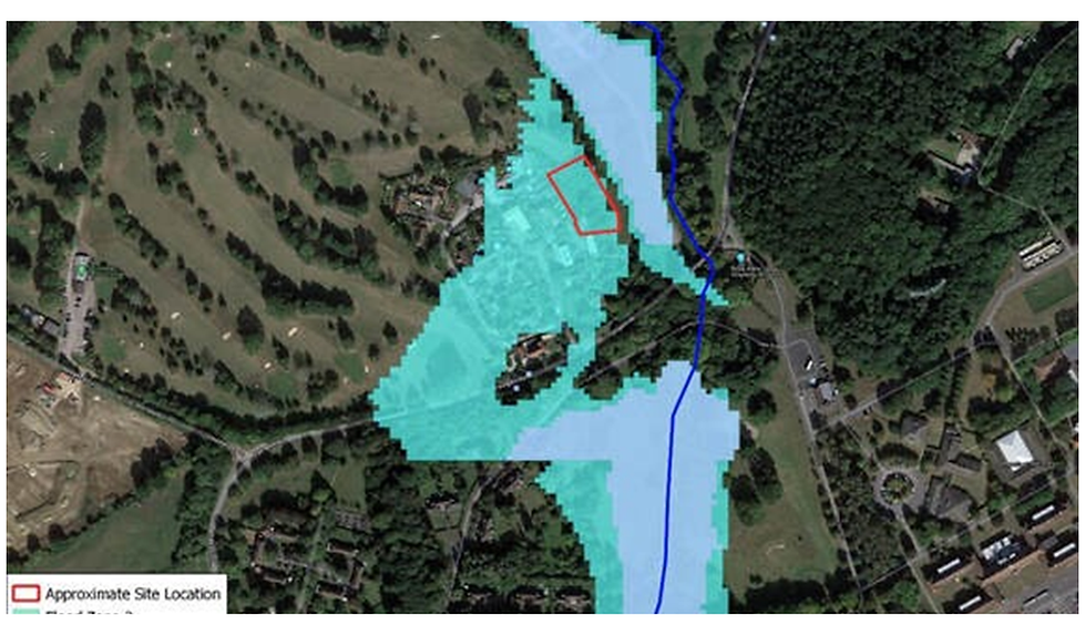
There are multiple instances that we come across every week where the EA flood zones don’t look quite right. Take this area that we looked at for a client recently. What’s wrong with this picture?

Well, for starters, the flood zones are not over the river and are misaligned. Secondly, there’s a great big straight edge to the flood zones to the south of the site. This is a relic from the national mapping and it happens more than you think. It can be very frustrating for residents, businesses, and potential developers to be caught out by this. Despite the fact the flood zones are obviously incorrect, to change them you have to prove they are wrong and correct them (usually). This is something that Aegaea can help with through a flood map challenge.
Need to challenge a flood model? Our team are ready to support you.
What is a Flood Map Challenge?
A flood map challenge is a formal process that you can enter with the Environment Agency to have the flood zones changed as a result of improved, detailed flood modelling. This is a way that the flood maps get better, with increased information and detail being put into them both as incremental updates and challenges.
Aegaea can help you with this flood map challenge process because it can be difficult and often requires flood modelling or the interrogation of flood risk data to happen. Typically this process involves;
- Reviewing the existing flood map and available flood history data.
- Giving advice about whether a flood map challenge is likely to be successful.
- Undertake detailed flood risk modelling and analysis with which to formally challenge the flood zone classification.
- Providing flood risk support and technical flood modelling assistance throughout the whole process.
There is never a guaranteed success with these things – the burden of proof lies with the applicant, but the benefits of succeeding can often be huge.
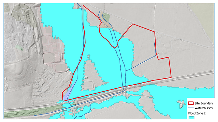
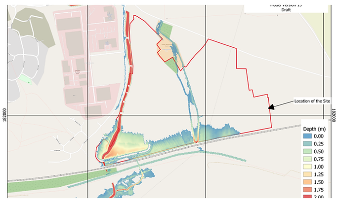
Take the below site for example. Here, we were successful in challenging the flood mapping.
Before

After

The applicant here knows now that their site application, upon successful completion of a flood map challenge, can provide more units and can develop more of their land by removing some 20 hectares of site from flood zone 2 and 3.
Flood Map Challenges – Who are they for?
You will likely be able to gain benefit from a flood map challenge if you are a:
- Property Developer – you can use a successful flood map challenge to help increase site development potential
- Property owner – you can use a flood map challenge to reduce your insurance burdens
- Businesses – you can use a flood map challenge to enable changes of use, expansion plans, and reduce insurance costs.
If you are a developer looking at the EA flood maps and see anything odd like the examples that we’ve shown here, then give us a call and we’ll look into it for you. We always provide a free consultation and we will never suggest expensive studies for no reason.
If there is a realistic chance of success for a flood map challenge we will always let you know – and if we believe that the flood zones are firm and reasonable then we’ll tell you (even if they are accurate, we can still help you with your development by looking at attenuation, risk reduction, flood evacuation and drainage strategies of course!)
Request your free, expert quote now
Aegaea work alongside home owners, private developers, planning consultants, architects, local authorities, international development agencies and contractors. Aegaea know exactly how to help you.