What is a Critical Drainage Area?
Critical Drainage Areas seem simple to understand, but we reckon you'll learn something from this article.
Here's a helpful guide for what you need to know and how it might relate to your potential planning application.
What is a Critical Drainage Area?
A Critical Drainage Area (CDA) is helpfully defined by the Drain London Project as
“an area where there are known flooding problems. Will be a discrete geographic area (usually a hydrological catchment) where multiple and interlinked sources of flood risk (surface water, groundwater, sewer, main river and/or tidal) cause flooding in one or more Local Flood Risk Zones during severe weather thereby affecting people, property or local infrastructure.”
So, Critical Drainage Areas are areas where development could have an influence on the risk of flooding within a ‘Local Flood Risk Zone’ (LFRZ). Local Flood Risk Zones are defined by Drain London as:
“Discrete areas of flooding that affect houses, businesses or infrastructure. The LFRZ is defined as the actual spatial extent of predicted flooding in a single location.”
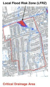
The image below shows an example of a LFRZ, within a Critical Drainage Area. A Critical Drainage Area can contain one or more LFRZs. Outside of London, LFRZs are sometimes referred to as “wet spots” or “hotspots”.

In the example above, the CDA comprises the upstream catchment which contributes to flooding in the LFRZ. However, CDAs can also include areas downstream of the LFRZ if they could influence flood risk within the LFRZ.
So, am I at risk of flooding if my site is located in a CDA?
There is a common misconception that CDAs indicate that a site is at risk of flooding, but as set out above, the definition shows that whilst there may be known flooding issues within the CDA, it also includes the wider hydrological catchment to encompass the surrounding area.
Changes to a site within the CDA could improve/worsen the risk of flooding in the LFRZ. CDAs are therefore used to denote areas where mitigation measures could be implemented to reduce the flooding experienced within the LFRZ.
Will I require a Flood Risk Assessment in a CDA?
Another general misconception is that an FRA is required for all development located within a CDA.
One or more CDAs generally form part of larger Policy Areas (PA). Within these Policy Areas, the Local Planning Authority (LPA) can set more stringent policies in respect to Flood Risk and Drainage in order to minimise or mitigate impacts to LFRZs. Such as guidance on general policy across the study area. For example, the use of soakaways in new development or specific validation requirements such as preparation of a Sustainable Drainage assessment or FRA.
An example is the London Borough of Southwark. All of the CDAs in Southwark fall within one Policy Unit. Whilst the Southwark Local Plan does not include policies specific to CDAs, the Local Validation checklist states that a Flood Risk Assessment is required for ‘Major applications in Critical Drainage Areas for surface water flooding’.
Therefore, you are only required to prepare an FRA in a CDA if required in accordance with Local Planning requirements.
Aegaea has information on CDAs across the UK and can advise you whether there are any additional design or submission requirements for your application in line with the relevant Local Planning obligations.
But the NPPF states an FRA is needed for ‘Areas with Critical Drainage Problems’?
Paragraph 167 of the NPPF states that “Where appropriate, applications should be supported by a site-specific flood-risk assessment” which is supported by Footnote 55;
“A site-specific flood risk assessment should be provided for all development in Flood Zones 2 and 3. In Flood Zone 1, an assessment should accompany all proposals involving: sites of 1 hectare or more; land which has been identified by the Environment Agency as having critical drainage problems; land identified in a strategic flood risk assessment as being at increased flood risk in future; or land that may be subject to other sources of flooding, where its development would introduce a more vulnerable use.”
Another common misconception is that Footnote 55 is referring to CDAs. Aegaea has contacted the EA to gain clarification and the EA has confirmed that CDAs are not considered as “land which has been identified by the Environment Agency as having critical drainage problems”. The EA further advised that CDAs are not defined by the Environment Agency (EA). CDAs were defined as part of the Lead Local Flood Authorities role to identify areas affecting LFRZs.
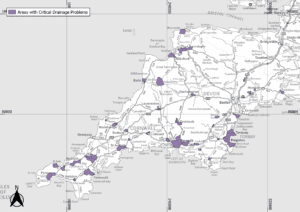
“Land which has been identified by the Environment Agency as having critical drainage areas” have a separate, yet similar, function and are referred to as ‘Areas with Critical Drainage Problems’ (ACDPs)
The ACDPs only fall within the south-west river basin district and are shown in the image below. Sites within these areas are required to prepare a Flood Risk Assessment in accordance with Footnote 55 of the NPPF.

Aegaea can advise whether you require an FRA because your site is located within an ACDP.
Aegaea are here to advise you.
If you are proposing a new development that is located in either a CDA or ACDP and want to understand the planning requirements or are unsure if your site is within a CDA or ACDP then Aegaea would be happy to assist. We can provide you with advice on your site and provide a free no-obligation quote and preliminary site assessment.
Please contact our team with the address of your site and what you are proposing to do either by using the website contact form or email us at enquiries@aegea.com. You can reach a member of the team on 020 8156 6076 if you wish to discuss over the phone.
About the Author
Request your free, expert quote now
Aegaea work alongside home owners, private developers, planning consultants, architects, local authorities, international development agencies and contractors. Aegaea know exactly how to help you.