What Is A Flood Risk Assessment? And What Do All The Flood Zones Mean?
A Flood Risk Assessment is integral to your planning application; the type, complexity and cost of that flood risk assessment will vary depending on the type and location of your development.
The National Planning Policy Framework (NPPF) states that:
“A site-specific flood risk assessment should be provided for all development in Flood Zones 2 and 3. In Flood Zone 1, an assessment should accompany all proposals involving: sites of 1 hectare or more; land which has been identified by the Environment Agency as having critical drainage problems; land identified in a strategic flood risk assessment as being at increased flood risk in future; or land that may be subject to other sources of flooding, where its development would introduce a more vulnerable use.
To comply with the NPPF, a FRA must be submitted for planning applications for developments within flood zones 2 and 3 (medium or high risk of fluvial or tidal flooding) and for all developments of 1 hectare or greater located in flood zone 1 (low risk).”
An FRA should be appropriate to the scale, nature, and location of the development, identify and assess the risk from all sources of flooding to and from the development, and demonstrate how any flood risks will be managed over the lifetime of the development.
Any hydrological impacts should be assessed, including an assessment of impacts on surface water runoff and impacts to the drainage network, to demonstrate how flood risk to others will be managed following development and taking climate change into account.
The Planning Practice Guidance (substantially revised in March 2015 concerning drainage) requires that sustainable drainage systems be considered and included where practicable, in line with DEFRA Technical Standards.
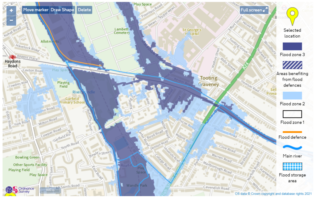
What Do The EA Flood Zones Mean?
There are four EA flood zones: Flood Zones 1, 2, 3a and 3b.
But what do they mean?

Flood Zone 1 Meaning
Flood Zone 1 is the lowest-risk area within England.
It is defined by the Environment Agency as “land assessed as having a less than 1 in 1,000 annual probability of river or sea flooding (<0.1%)”.
In this flood zone, any type of development is permitted as long as other planning policy rules are followed.
Depending on the size of your development, you may not need a flood risk assessment, but it is worth checking with Aegaea to see whether one would be required.
Flood Zone 2 Meaning
Flood Zone 2 is land assessed as having between a 1 in 100 and 1 in 1,000 annual probability of river flooding (1% – 0.1%), or between a 1 in 200 and 1 in 1,000 annual probability of sea flooding (0.5% – 0.1%) in any year.
In Flood Zone 2, you will need a flood risk assessment to apply for planning.
Flood Zone 3a Meaning
Flood Zone 3a land is assessed as having a 1 in 100 or greater annual probability of river flooding (>1%) or a 1 in 200 or greater annual probability of flooding from the sea (>0.5%) in any year.
In Flood Zone 3a, you will need a flood risk assessment to apply for planning.
Flood Zone 3b Meaning
Flood Zone 3b is defined as the functional floodplain – you can’t see it on the EA flood maps, but it is there.
It is, nominally land assessed as having a 1 in 20 or greater annual probability of river flooding (5% probability of flooding in any given year).
The functional floodplain is found within a Local Authorities’ Strategic Flood Risk Assessment (SFRA).
Typically, development in the functional flood plain is not allowed – however, if you know what you’re doing, there are ways around some policies.
Just ask Daniel Cook (daniel@aegaea.com) for a free consultation!
Why are Flood Zones and Vulnerability Important?
The planning policy in England is a risk-based system – the more vulnerable your development is, the more restrictions there are on where you can put it.
This has the effect of trying to move development to areas of least risk. While this is a laudable goal, it isn’t always practical (and those flood zones aren’t always correct)
Vulnerability is assessed based on the type of development – housing for example is “more vulnerable”, but are classed as “highly vulnerable” if you have a habitable basement.
Commercial premises like shops and cafés are “less vulnerable”, unless they store potentially dangerous items that don’t mix well with water.
You can find the full list of classifications on the government’s website, or speak to one of our consultants about a personalised approach.
Depending on the type of development and the flood zone, you might need to go through an exception (maybe a sequential test too) test to prove that your development should be able to take place.
You can see the checklist here or talk to us about how we would approach your site.
What Are Flood Risk Assessments?: Summary
Flood Risk Assessment guidance is a little complicated – it is based on geography, type and vulnerability.
There are a lot of different niche areas of the legislation that you need to know about – that’s where Aegaea come in.
Our consultants are experts in policy and development for planning.
We know all the ways of reviewing a site and making sure that we offer you the best advice and approach for your development.
Request your free, expert quote now
Aegaea work alongside home owners, private developers, planning consultants, architects, local authorities, international development agencies and contractors. Aegaea know exactly how to help you.