Updated Peak Rainfall Allowances May 2022
Published on the 10th of May, the Environment Agency has rolled out changes to peak rainfall intensity allowances across Management Catchments in England. The update removes the standard 40% uplift in rainfall to account for climate change and instead implements a regional variation in allowances, similar to the way that peak river flow updates were introduced in July 2021 (see those here – they will be important later!).
Peak Rainfall Intensity Changes
Peak rainfall changes now vary spatially by management catchment unit, and over time – with different allowances for different epochs of climate change – that means different rainfall climate change uplift will apply depending on the type of development and it’s location. There are also different allowances for rainfall intensity for different return periods or annual exceedance probability (AEP) events, even within the same epoch. To pair with this, the EA has released updated guidance on how to assess peak rainfall changes as part of the government guidance, which further complicates rainfall assessments.
Updated Guidance on assessing peak rainfall for development
The updated guidance now sees the requirement to run additional return periods and to be sized for the upper end 1% AEP scenario.
Development with a lifetime up to or beyond 2100
This includes development proposed in applications or local plan allocations. For flood risk assessments and strategic flood risk assessments assess the upper end allowances. You must do this for both the 1% and 3.3% annual exceedance probability events for the 2070s epoch (2061 to 2125). Design your development so that for the upper end allowance in the 1% annual exceedance probability event:
- there is no increase in flood risk elsewhere
- your development will be safe from surface water flooding
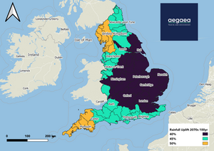
There are 48 management catchments where developers will now have to account for increased climate change beyond the existing 40%, these are:
Dee, Aire and Calder,Swale, Ure, Nidd and Upper Ouse, Alt and Crossens, Derwent North, WestDouglas, Irwell, Kent and Leven, Lower Mersey, Lune, RibbleSouth, West Lakes,Upper Mersey, Weaver Gowy, Wyre, Northumberland Rivers,Tees,Tyne,Wear,Avon Bristol and North Somerset Streams, Severn,Middle Shropshire,Severn Uplands,South East Valleys, Usk, Wye MC,Eden and Esk, Till, Tweed, Waver and Wampool, Adur and Ouse, Arun and Western Streams, Cuckmere and Pevensey Levels, East Hampshire, Isle of Wight, New Forest, Rother, StourTest and Itchen, Avon Hampshire, Dorset, East Devon, North Cornwall, Seaton, Looe and Fowey, North Devon, South and West Somerset, South Devon, Tamar, West Cornwall and the Fal, Wey and tributaries.

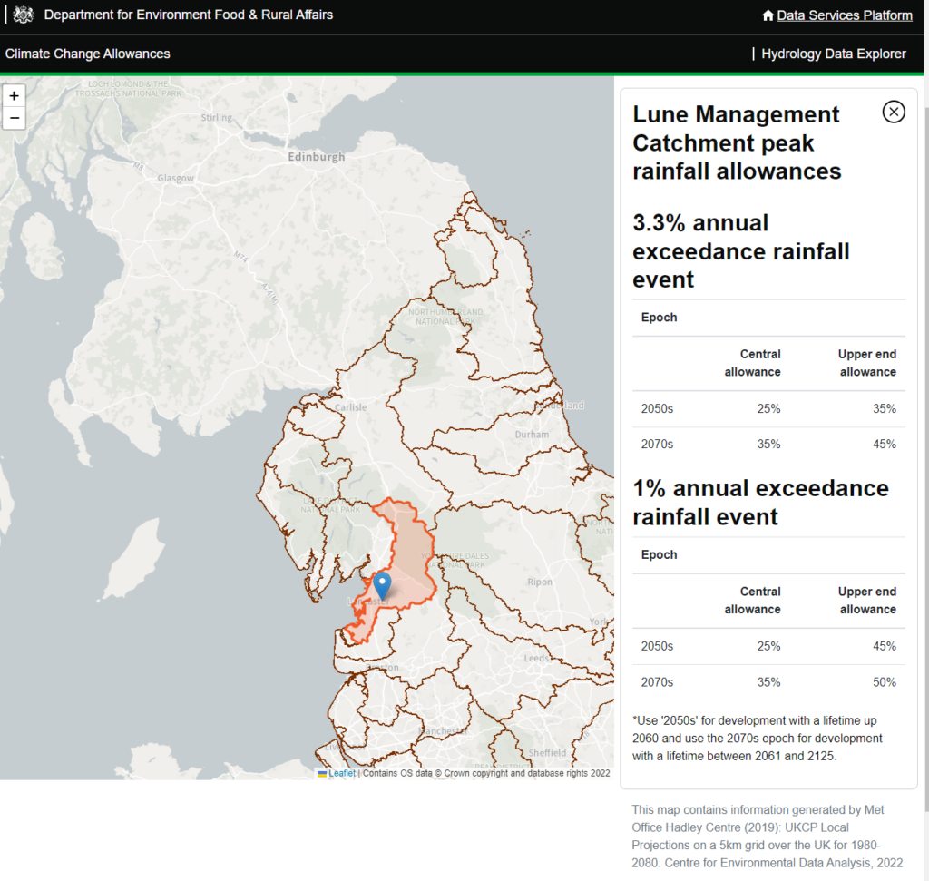
No catchments will see a reduction in peak rainfall allowance for climate change. Let’s look at the Lune catchment as an example.

Assessment has to be made on the 3.3% AEP including 45% climate change and designed for the 1% AEP plus 50% climate change allowance (probably, see later).
What regions are affected by the updated rainfall allowances?
Broadly, the impacts of increased climate change will be seen in the South East, South West and North West of the UK.
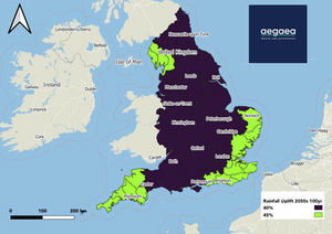
Rather confusingly, because of the guidance change, you need to also consider increased climate changes in the Broadland Rivers, Combined Essex, East Suffolk, Darent and Cray, Medway, North Kent and South Essex catchments as their climate change allowance for the 2050s is greater than that anticipated for the 2070s!

Large, Rural Catchments
The assessment of climate change also has to take into account the rural vs. urban nature of the catchment as well as the size of the catchment.
“Use [peak rainfall allowances] in small catchments (less than 5 sq km), or urbanised drainage catchments. For large rural drainage catchments use the peak river flow allowances. A drainage catchment is urban if the land use is a town or city. If you are unsure if your catchment is urban or rural, please contact the lead local flood authority.”
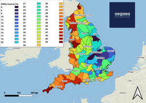
The implication of the guidance is that for developments in large catchments that are predominantly rural, peak rainfall allowances are taken from the fluvial climate change allowances. In the case of the Lune catchment above, this could result in rainfall allowances being up to 52% using the central and 68% higher, while 92% using the upper end. Here’s the river flow map to refresh your memory of uplifts:

How can we help?
Now that we have gotten to the bottom of all the implications, there are still some unanswered questions, particularly in regards to the application of uplifts using peak river flow adjustments and which epoch to use. Aegaea are currently engaging with the Environment Agency to ensure that our understanding is correct and that the application of climate change is correct across all our projects.
There is also a quite sizeable shift in the policy – the transition from the central allowance (50% confidence interval) to the upper end allowance (95% confidence interval) – why the change between rainfall and peak flow for catchments? This is something for us to get our heads around!
Request your free, expert quote now
Aegaea work alongside home owners, private developers, planning consultants, architects, local authorities, international development agencies and contractors. Aegaea know exactly how to help you.