TAN15 Wales Flood Risk Policy Updates 31 March 2025
The Welsh Government has recently updated Technical Advice Note 15 (TAN 15), providing revised guidance on planning policies related to development and flood risk.
The Welsh Government has released a long-awaited update to Technical Advice Note 15 (TAN15), changing how flood risk is assessed and managed in planning decisions across Wales. The new guidance introduces updated flood maps, revised zones and stricter policies that will significantly affect future development, particularly in areas previously considered low risk.
Key Takeaways
- Development Advice Mapping (DAM) has been discontinued with DAM references and DAM Flood Zones ((C1, C2, B and A) removed
- Flood Map for Planning (FMfP) shows more land at risk of flooding in comparison to DAM
- Inclusion of a new ‘Defended’ Flood Zone and associated policies for new development within a defended area
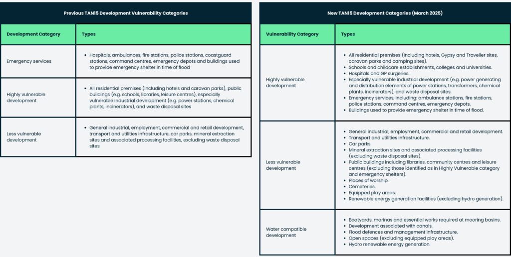
- There have been alterations to the vulnerability classifications, including category changes
- Removal of the Justification Test (Sequential Test) in favour of defining acceptability criteria of flood consequences
- No new highly vulnerable development will be permitted in Zone 3, regardless of the conclusions of a Flood Consequence Assessment, with the exception of proposals essential to the Development Plan Strategy
- New development on greenfield sites at risk of flooding will face greater scrutiny and is likely to be strongly discouraged.
- Redeveloping existing, previously used land in flood-prone areas might be more acceptable under specific conditions, likely involving robust flood resilience measures
- There is now a greater emphasis on detailed assessment of flood depths and velocities within Flood Consequence Assessments
-
What is TAN15?
TAN 15 (Technical Advice Note 15) is Welsh Government policy that helps planning authorities manage development with a view to mitigating flood and coastal erosion risk. The guidance supports national planning policies by setting out how flood and erosion risks should be considered in the planning process.
The original TAN15 was issued in July 2004, with an updated version scheduled to come into effect on December 1, 2021. However, following significant concerns from local authorities, developers, and other stakeholders regarding its suitability and potential impacts, its implementation was suspended to allow for additional consultation.
In response to the feedback received, the Welsh Government initiated another draft and consultation in January 2023 to consider additional amendments to TAN15. On 31 March 2025, the Welsh Government finally released the first update to TAN 15 since its initial publication in 2004. It provides everyone with long-overdue clarity concerning development and flood risk in Wales
The new TAN came into immediate effect on 31st March 2025, fully superseding the 2004 document and applies to all new planning applications.
The key takeaway summary from the new TAN15 document is that it emphasises a risk-based approach, utilising the Flood Map for Planning to balance the likelihood of flooding events against the vulnerability of developments.
Development Advice Map (DAM) Discontinued & Replaced With Flood Map for Planning
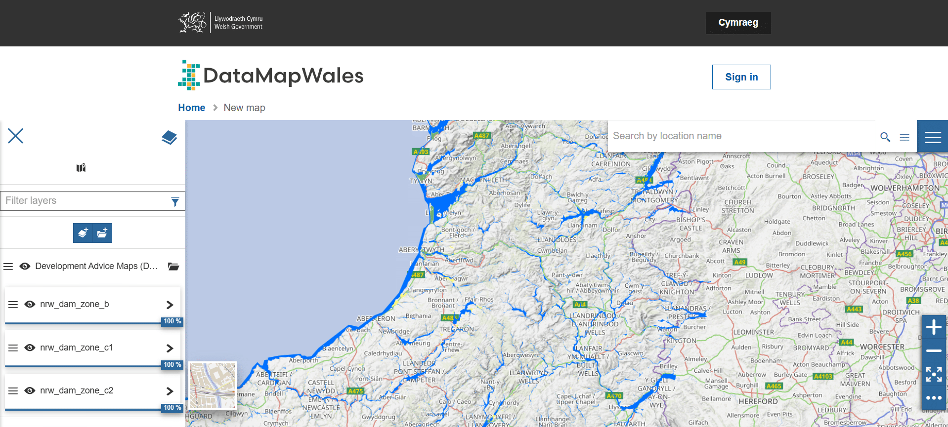
The Development Advice Map (DAM) has been discontinued and replaced with Flood Map for Planning (FMfP). DAM is to be retained on DataMap Wales for a period of 8 weeks to inform planning schemes currently being determined. It will be removed from this viewer sometime after May 2025.

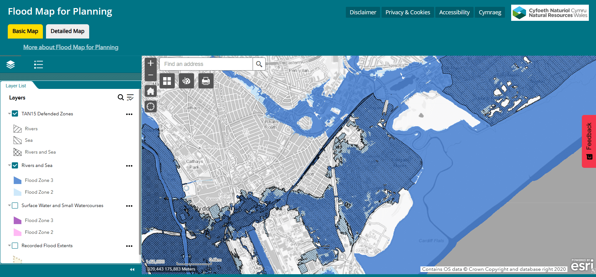
Flood Map for Planning (FMfP)
The Flood Map for Planning data shows more land at risk of flooding than the discontinued Development Advice Maps. This is because as data improves, our understanding of which areas may be at risk increases.
The Flood Zones within FMfP shows the undefended risk of flooding from Rivers, the Sea and from Suface Water & Small Watercourses.
Flood Zone 3 displays the extent of flooding from:
- rivers with a 1% (1 in 100) chance or greater of happening in any given year, including an allowance for climate change.
- the sea with a 0.5% (1 in 200) chance or greater of happening in any given year, including an allowance for climate change.
- Surface water & small watercourses with a 1% (1 in 100) chance or greater of happening in any given year, including an allowance for climate change.
Flood Zone 2 displays the extent of flooding from:
- Rivers with less than 1% (1 in 100) but greater than or equal to 0.1% (1 in 1,000) chance of happening in any given year, including an allowance for climate change.
- the Sea with less than 0.5% (1 in 200) but greater than or equal to 0.1% (1 in 1,000) chance of flooding in any given year, including an allowance for climate change.
- Surface water & small watercourses with less than 1% (1 in 100) but greater than or equal to 0.1% (1 in 1,000) chance of happening in any given year, including an allowance for climate change.
Source: https://datamap.gov.wales/layergroups/inspire-nrw:FloodMapforPlanningFloodZones2and3
Flood Map for Planning is due to be updated every May and November.

New ‘Defended’ Flood Zone
The TAN15 update includes a new Defended Flood Zone. TAN15 Defended Zones are protected by defences that shield against at least one major source of flooding, whether from the sea, rivers, or sometimes both. However, some areas within these zones could still be at risk from other flooding sources, so it’s crucial to evaluate all potential risks. Additionally, any new development within TAN 15 Defended Zones must incorporate resilience and resistance measures to ensure it remains safe, flood-free, and adequately addresses the requirements outlined in the Flood Consequences Assessment.
Alterations to Vulnerability Classifications
- The ‘emergency services’ category has been removed, with these uses now classified under Highly Vulnerable.
-
A new category has been introduced: Water Compatible, recognising developments that can tolerate or function during flood events.
-
Some land use definitions have been revised, such as public buildings (e.g. libraries), which have been reclassified from Highly Vulnerable to Less Vulnerable.

Removal of the Justification Test
The old Justification Test has been replaced with a greater focus on a plan-led approach to decision-making regarding development in flood risk areas.
The old Justification Test required developers to demonstrate that the location of a proposed development in a Flood Zone was necessary (for example, to support a regeneration initiative or strategy for sustaining an existing settlement, or for specific employment needs) and cannot be located in a lower-risk area.
The revised methodology within TAN15 prioritises a decision-making framework through a comprehensive understanding of flood risk. It stresses the necessity for Local Development Plans to strategically allocate land for development, integrating flood risk considerations based on the Flood Map for Planning and SFCA evidence.
The assumption is that flood risk considerations are expected to be integrated from the earliest stages of the planning process. This approach offers greater flexibility for redevelopment of previously developed land within flood risk areas, whilst tightening the rules for new development within the floodplain
In summary, TAN15 has replaced a criteria-based “Justification Test” with a broader, more strategic plan-led approach to development in flood risk areas. This approach emphasises integrating flood risk management into the planning process from the outset, with a focus on sustainable development, regeneration through the understanding of flood consequences.
Acceptability criteria for flooding consequences
If the planning authority is satisfied that a development proposed in a flood risk zone is acceptable, the justification will be in the knowledge that those developments may experience flooding and will need to be planned accordingly. A full understanding of the potential risks and consequences will be required to inform the planning authority in its decision.
There are requirements that must be in place for any development that is permitted to be located in flood risk areas. In all circumstances, developers and planning authorities should ensure the following conditions are met:
- No increase in flooding elsewhere
- Occupiers are aware of the flood risk
- Escape/evacuation routes present
- Flood emergency plans and procedures have been agreed and are in place
- Flood-resistant and resilient design
How will this affect my development?
In terms of how the flood risk will be applied to your planning application will depend on the vulnerability classification, flood risk zone, whether the site is defended and whether it is greenfield or previously developed.
Zone 1
In Zone 1 all vulnerabilities of use will be acceptable in principle provided that there is no increase in flooding elsewhere and flood-resistant and resilient design in locally defined areas of future or current flood risk are included.
Zone 2
Planning applications in Zone 2 require careful consideration and must be consistent with the acceptability considerations. They must also be accompanied by a FCA which clearly describes the flood risk and the risks must be acceptable.
Applications for new highly vulnerable development on greenfield land are only appropriate where the site has been allocated in adopted Development Plans.
Proposals for redevelopment on brownfield land of any vulnerability will need to assist, and be consistent with, the Development Plan strategy to regenerate an existing settlement or achieve key economic or environmental objectives.
Where proposals for redevelopment include residential use, local authorities should ensure that such uses do not occur at the ground floor level; they will also need to be compatible with the tolerable conditions and exhibit resilient flood design.
Zone 3
Planning applications in Zone 3 require the strongest justification.
No new highly vulnerable development on greenfield land should be permitted in Zone 3, regardless of the conclusion of any Flood Consequences Assessments and NRW will not consider these conclusions.
Other proposals will only be appropriate if they are essential to the Development Plan Strategy to regenerate an existing settlement or achieve key economic or environmental objectives. Any redevelopment proposal must be consistent with the acceptability considerations set out in TAN.
Water-compatible development is acceptable in all flood zones.
In addition, proposals which include residential development must ensure that such uses do not occur at the ground floor level.
Defended Zones
Applications for new development on Greenfield sites are not appropriate in Defended Zones unless they are allocated in development plans.
On brownfield sites, redevelopment proposals should not over-intensify use, nor should they reduce the area’s ability to absorb flood water, nor cause problems with flooding elsewhere.
All applications should consider opportunities to incorporate flood resilient design as appropriate, and any proposal involving highly vulnerable development must be compliant with the tolerable conditions.
How Aegea Can Help
The updated TAN 15 brings major changes to how flood risk is handled in planning across Wales. With stricter rules, new flood zone maps, and the removal of the old Development Advice Map, understanding the path forward is crucial for any development.
Aegaea’s expert Flood Risk Consultants have extensive knowledge in navigating flood risk policies and guidance in Wales. Get in touch for a free, unique quote bespoke to your requirements.
About the author
Request your free, expert quote now
Aegaea work alongside home owners, private developers, planning consultants, architects, local authorities, international development agencies and contractors. Aegaea know exactly how to help you.


