National Flood Risk Assessment 2 Update (NaFRA2)
The latest NaFRA update released on 28th January 2025 brings with it significant changes and for the first time accounts for the latest climate change projections when assessing flood risk. We’ve analysed what this means and the impact it may have on developments in England.
What is the National Flood Risk Assessment (NaFRA2)?
NAFRA2 (National Flood Risk Assessment 2) is an updated flood risk assessment model developed by the Environment Agency in England, building on the previous update to the National Flood Risk Assessment from 2018 and the original assessment 2014 (TBC). The data will inform government agencies, local authorities, and communities in planning and enhancing flood resilience measures.
Key Takeaways
- An increased number of areas are now considered at risk, meaning some locations that were once outside flood zones may now require further consideration including Flood Risk Assessments (FRAs).
- 6.3 million properties in England are in areas at risk of flooding by rivers, the sea or surface water.
- With current climate change predictions, 1 in 4 properties in England will be in areas at risk of flooding by mid-century.
- There are 48% fewer properties in areas at medium risk, many of which we now consider to be in high-risk areas.
- 4.6 million properties in areas at risk of flooding from surface water – this is a 43% increase from the previous assessment.
NaFRA vs NaFRA2 - What are the differences?
Increase of locations being considered at risk
The new NaFRA shows that around 6.3 million properties are now at risk of flooding, vs the previous figure of 5.2 million and then 5.7 million. When considering climate change projections, the total number of properties at risk is expected to increase to 8 million or around 1 in every 4 properties. The Environment Agency stress that the increase in properties considered at risk does not reflect a real-world increase in risk, but rather a better understanding of risk due to improvements in data, modelling and use of technology.

Surface Water Flooding
There are now 3 times as many properties at high risk of flooding from surface water than there are from flooding from rivers and the sea.
Around 4.6 million properties are at risk from surface water flooding, where heavy rainfall overwhelms drainage systems, leading to surface water runoff or flash flooding. This represents a 43% increase from previous assessments, primarily due to enhanced data, modelling, and technological advancements.
Over one-quarter of properties in areas at high flood risk from surface water flooding are in London (29.9%) – nearly a third of a million – 319,800. This is over 11 times as many properties as are in areas at high risk of flooding from rivers and the sea within London. This is followed by the East of England (15.9%), North West (11.5%) and South East (11.9%).
River and Sea Flooding
Approximately 2.4 million properties are at risk from river and sea flooding. While the overall number of at-risk properties remains stable, there is an 88% increase in properties classified at the highest risk level (greater than a 1 in 30 chance of flooding annually). This change is attributed to improved data and modelling techniques.
Climate Change Information
The climate change projections integrated into the latest National Flood Risk Assessment (NaFRA2) are derived from the UK Climate Projections 2018 (UKCP18), developed by the Met Office. These projections utilise advanced climate models to simulate potential future climate scenarios, providing detailed insights into variables such as temperature, precipitation, and sea-level rise across the UK.
NaFRA & Housing Targets
According to the 2023 Land Use Statistics*, approximately 10.4% of England’s land area falls within Flood Zone 3 (excluding flood defences). NaFRA update and the EA Flood Map for Planning set for release on 25/03/2025, this figure is likely to rise. As a result, the amount of land available for development that is not affected by flood risk could decrease, adding further pressure to the government’s ambitious housing target.
The South East, in particular, has some of the highest concentrations of existing properties at medium to high risk of flooding from rivers, the sea, and surface water, according to NaFRA data. It has also been identified as one of the largest contributors to the government’s target of 300,000 new homes per year, with 45,429 planned.
Read more in this article by The Guardian, with comments from our Director – Daniel Cook.
EA Flood Map for Planning Update
This isn’t the last change regarding flood risk from the Environment Agency due this year. On 25th March 2025 the Flood Map for Planning will be updated to incorporate the data from NaFRA2 including risk from surface water in addition to rivers and the sea and climate change as well as the ability to switch on and switch off defences
It’s worth noting that the EA Flood Map for Planning is a representation of land without flood defences. For example, Hull and Central London both benefit from significant flood defences but still have land recognised in flood zones. This is a precautionary approach to reflect the potential risk if defences fail or are overtopped.
What does this mean for my development?
With so much change in the mapping and data, there is a greater need to understand the national and local policies that exist to regulate appropriate development in flood-affected areas. Those policies can be acted upon effectively whilst promoting appropriate mitigation techniques to support development.
You only have to look at the last twenty years.

National Policy is structured to mitigate risk and promote appropriate development.
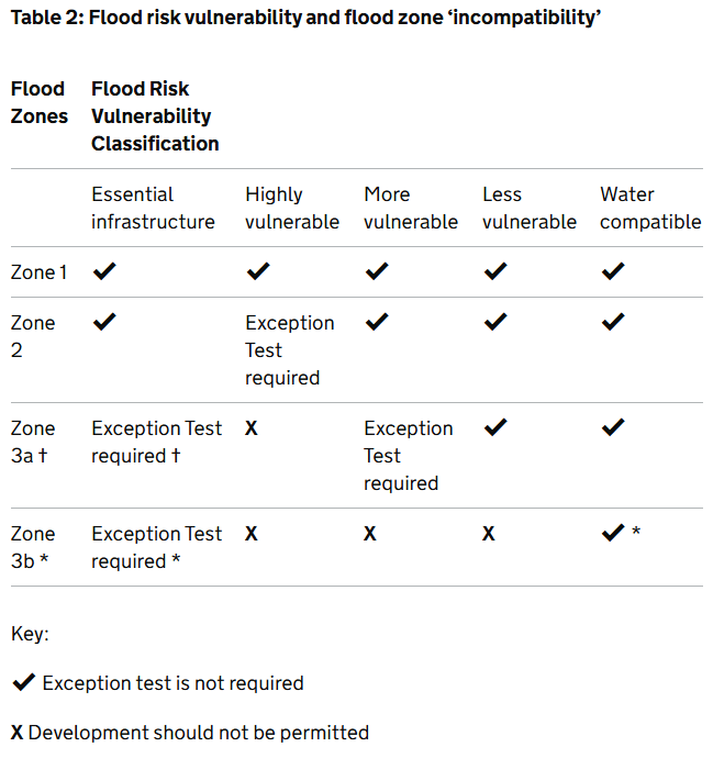
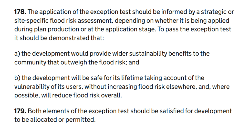
With focus on the NPPF, Paragraph 170 identifies that development should be directed away from high flood risk areas. It further discusses that where development is necessary in such areas, the development should be made safe for its lifetime without increasing flood risk elsewhere. The subsequent paragraphs direct developers, local authorities and professional consultants on how to evolve a site for development whilst working with flood risk not just now but in the future tied to the lifetime of the development, paragraph 172. Developments promoted in areas of flood risk must comply with Paragraph 178 & 179. The exception test with both elements needing to be passed. To understand whether the development needs to pass the exception test reference to the Planning Practice Guidance – Flood Risk and Coastal Change, Table 2: Flood risk vulnerability and flood zone ‘incompatibility’. To understand whether your development is appropriate, reference to this table is required as well as Annex 3 of the NPPF and checking the flood zones against EA flood map for planning or appropriate SFRA.
Above all else, Footnote 63 of the NPPF promotes that a site-specific Flood Risk Assessment should be conducted even for those cases where the development is NOT subjected to the Exception Test as per the requirements below.
‘A site-specific flood risk assessment should be provided for all development in Flood Zones 2 and 3. In Flood Zone 1, an assessment should accompany all proposals involving: sites of 1 hectare or more; land which has been identified by the Environment Agency as having critical drainage problems; land identified in a strategic flood risk assessment as being at increased flood risk in future; or land that may be subject to other sources of flooding, where its development would introduce a more vulnerable use’


It is recognised that there is a need for housing, there will be a greater risk in the future from flooding as a result of the outputs from NAFRA and the incoming Flood Map for Planning.
Concerns are raised around the appropriate drainage of developments. Schedule 3 of the Flood and Water Management Act has not been fully adopted. However, the latest NPPF has made updates to not only flood risk but also how we should mitigate and manage surface water runoff generated from new development. Paragraphs 181, item c, & 182 promote better sustainable drainage practices for all developments unless there is clear evidence that this would be inappropriate to do so.
Flood risk is complex, policy is intricate and disparate. Working with experts to advise, inform and mitigate flood risk is important for planning, operation of the development and insurance.
Talk to the experts
Aegaea’s expert Flood Risk Consultants can advise on the changes to NaFRA and how they could affect your property or development plans. Get in touch to speak to a member of our team.
Get accurate insight into flood risk in 90% less time. Aegaea has developed FloodMetric, your first step in assessing your property, a site of interest or a future development site. Find out more.
Sources
The Guardian – “More than 100,000 homes in England could be built in highest-risk flood zones”
https://www.theguardian.com/environment/2025/feb/08/more-than-100000-homes-in-england-could-be-built-in-highest-risk-flood-zones
Gov.uk – “Land use statistics: England 2020 – statistical release”
https://www.gov.uk/government/statistics/land-use-in-england-2020/land-use-statistics-england-2020-statistical-release
About the Author
Request your free, expert quote now
Aegaea work alongside home owners, private developers, planning consultants, architects, local authorities, international development agencies and contractors. Aegaea know exactly how to help you.


