Flood Map Planning: How It Affects Development Applications
What Is Flood Map Planning and Why Does It Matter?
The Flood Map for Planning is a screening tool produced by the Environment Agency to help determine whether development proposals will require a Flood Risk Assessment (FRA) as part of a planning application. It does not definitively establish the level of flood risk to a site, but rather indicates whether a more detailed assessment of risk is required.
The Flood Map for Planning classifies all land in England into three Flood Zones – Flood Zone 1, Flood Zone 2, and Flood Zone 3.
The Flood Zone definitions are set out in the National Planning Policy Guidance and are as follows:
-
Flood Zone 1 – land assessed as having a less than 1 in 1,000 annual probability of river or sea flooding (<0.1%).
-
Flood Zone 2 – land assessed as having between a 1 in 100 and 1 in 1,000 annual probability of river flooding (1% – 0.1%), or between a 1 in 200 and 1 in 1,000 annual probability of sea flooding (0.5% – 0.1%) in any year.
-
Flood Zone 3 – land assessed as having a 1 in 100 or greater annual probability of river flooding (>1%), or a 1 in 200 or greater annual probability of flooding from the sea (>0.5%) in any year.
Flood Zones 1, 2 and 3 are broadly considered to be low, medium and high risk respectively.
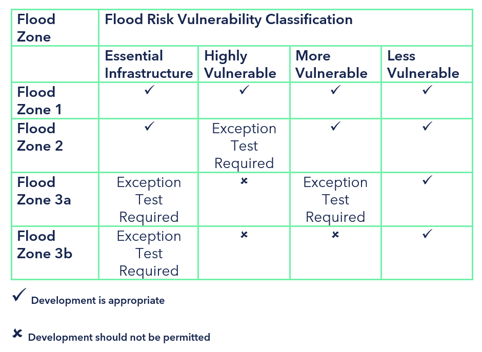
Flood Zone 3 is split into zones 3a and 3b, where 3b is the functional floodplain with its own rules and regulations.
The Flood Zones are largely informed by strategic scale models, but may also be informed by detailed hydraulic model information and historic flood extents.
How Flood Map Planning Zones Affect Your Development Proposal
Depending on the size of the site and the Flood Zone in which it is located, you may need to prepare a flood risk assessment, exception test and a sequential test.

Do You Need a Flood Risk Assessment in Flood Zone 1?
That depends. Not every watercourse is represented within the Flood Map for Planning, meaning some land may be shown to be located within Flood Zone 1 (low risk) although a watercourse may run through or be located within the vicinity of the site. If this is the case with your site, please get in touch and we will be able to advise you on the best course of action to keep your development safe and to ensure a smoother journey through the planning system.
Flood Map Planning Discrepancies: Can Flood Zones Be Wrong?
As Flood Zones are often based on strategic scale information, it is not uncommon for Flood Zones to look incorrect or unusual. Please refer to our page on Flood Map Challenges for more information on how we can help you progress in this situation.
Request your free, expert quote now
Aegaea work alongside home owners, private developers, planning consultants, architects, local authorities, international development agencies and contractors. Aegaea know exactly how to help you.