Surface Water Flooding: London

Background
In 2015 national planning policy for SuDS was strengthened to make SuDS a requirement in all new major developments. Since this update the government has published three more versions of the NPPF, 2018, 2019 (updates) and 2021 that have superseded the 2012 edition.
The importance of introducing SuDS into National Policy can be clearly understood when we know that surface water flooding is the most widespread form of flooding in England, with around 3.2 million properties at risk. We also know that this risk is increasing because of climate change and population growth change and population growth. Surface Water Flooding is caused by a combination of factors including intense rainfall, soil permeability, topography, drainage system capacity and maintenance, and physical barriers such as buildings.
The Government produced 22 actions in a Surface Water management action plan, July 2018. Good progress has been made with the 22 actions; some have been completed whereas others are still on going. As a country we have developed many technologies and systems to improve our understanding of surface water flood risk. The government provided surface water flood risk mapping grants. At the 2018 Autumn Statement the government provided an extra £13.1 million to tackle the risks from flooding and climate change. This included a £2 million grant project to enable lead local flood authorities to improve surface water flood risk mapping.
In 2017 detailed local information in published surface water maps covered just 990 square kilometres. In 2018 the government provided £2 million of grant funding to improve mapping data in 28 lead local flood authorities, to improve mapping data across 2,400 square kilometres. In 2020 the Environment Agency also made it easier for other organisations to supply additional surface water flood risk data for incorporation into the ‘Check the long-term flood risk’ for an area in England information service.
These initiatives mean that from summer 2022, the proportion of England covered by local detailed mapping for surface water will increase to some 3,500 square kilometres. This will provide more detailed information on surface water flood risk to an additional 3.3 million people and 1.4 million properties. After the update a total of 7.1 million people in 3 million residential properties will be able to access detailed information on their local surface water flood risk.
Our ability to better understand where areas could be at risk of flooding has improved through new technology, data capture and presentation of the data in the form of mapping. It has also allowed us to identify areas of high risk and how best to mitigate flooding in these areas through engineering in the form of SuDS, defences and working with nature in the form of natural flood management (NFM). Significant improvements have been made in recent years, one big question still remains.’
Why do we still have flooding from surface water events?
As SuDS have become more enforced, a review in 2018 was conducted by Government to understand the effectiveness of planning policy for Sustainable Drainage Systems. The review demonstrated that the majority of adopted local plans contained policies that clearly reflect the requirement do f the NPPF at that time. Just over 80% of all adopted local plans included SuDS policies that go further than national policy expectations (e.g. SuDS required for all developments regardless of location and scale). This proportion increases to 90% when only emerging local plans are considered.
Although the uptake to respond to the policy has been positive, there are still gaps post planning and implementation of SuDS. These gaps can become more crucial than the enforcement of policy. One key gap is maintenance. From the review conducted in 2018, it was discovered that 70% of all the planning applications analysed that included SuDS, it was unclear from the planning application documentation who is responsible for maintaining the SuDS. SuDS can only be as effective as intended if maintained. With no maintenance the SuDS can become inefficient and worst yet stop working entirely if so, poorly maintained.
In general, LPAs had no specific checking regimes in place to ensure that SuDS had been constructed as agreed. A reactive approach to issues was generally taken, with checking undertaken following complaints or issues raised by third parties. One LPA stated that they were very proactive in checking the larger strategic sites, but resource issues prevented wider checking.
As professionals, Aegaea understand that poor maintenance of surface water drainage systems can be a large contributing factor to an area flooding. Although the review in 2018 focused on policy adoption and planning applications promoting SuDS, it became clear from the review that there was much confusion on who was responsible for the maintenance of assets and that One third of LPA officials were unsure of the extent to which SuDS were adopted.
So, what does this all mean in a real world situation?
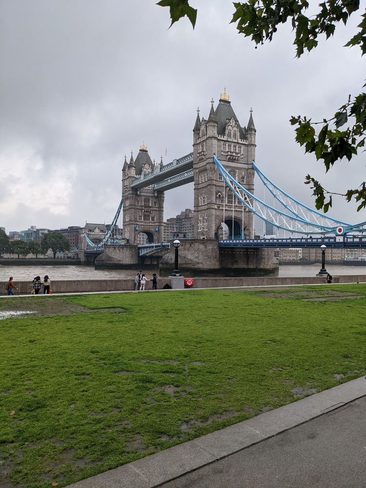
Aegaea were recently asked to support ITV News London to better understand the flooding around Tower Bridge. (Here’s Daniel Cook looking like a pro – he’s available for birthday appearances and his fees are quite reasonable)

From a review of the bridge our team were able to identify 4 contributing factors as to why the carriageway of the Bridge flooded,
1. Intense Rain fall burst after a period of dry warm weather. Surface water flooding in an urban environment is a capacity problem where intense, high volume rain exceeds the capacity of the drainage system.
Using a high-resolution climate models which can capture localized thunderstorm distribution has been highlight by the The Met Office as an area of further development which is critical to future predictions, especially in the summer months. Their current prediction is that summers may tend to become drier overall but when it does rain it will fall in heavier bursts, which has implications for flash flooding. (https://www.metoffice.gov.uk/research/climate/understanding-climate/uk-extreme-events-_heavy-rainfall-and-floods).
2. Physical Barriers – Tower Bridge approach carriageway is lined by counter terrorism barriers. Some of the barriers appeared to have been constructed over the carriage way storm drainage system and as such the water was able to collect within the channel created by the barriers

3. Maintenance – A review of the counter terrorism barriers demonstrated that they had been constructed with drainage features to allow to flow from the carriage way to the road drainage and be conveyed to the connecting road drainage. These drainage features were heavy with silt and therefore indicated maintenance was required/could have benefited the situation.

4 – Topography- the worst affected area was to the North. A walk over of the bridge demonstrated that the bridge gradient fell toward the North and high volumes of water ponding in a depression.
Conclusion
As a result of all the contributing factors, the rainwater was conveyed by the barriers, unable to drain efficiently as intended due to the maintenance of the outlets being blocked. As such the water collected toward the northern end of the bridge and began to pool whilst increasing depth.
Aegaea are in agreement with Minister Rebecca Pow that Surface water flood risk is often localised and complex. It means ensuring culverts, drains, small watercourses and ditches are able to deal with often heavy rainfall which could overwhelm them. Local councils, highways authorities, water companies, landowners and regulatory bodies have a role to play and must work together. Surface water flooding is the most widespread form of flooding in England, with around 3.2 million properties at risk, if poor practice is applied than these numbers are likely to increase especially with climate change, population growth combined with more housing and urbanisation.
We’re ready to meet the challenge and integrate good design in our schemes and promote best practise across the industry. Get in touch with us at enquiries@aegaea.com, or any of our team members, who will be happy to help.
References and Further Reading
Government Update on Surface Water Management – July 2021
https://www.gov.uk/government/publications/surface-water-management-a-government-update
A review of the application and effectiveness of planning policy for Sustainable Drainage Systems (SuDS) – August 2018.
Multi-billion pound investment as government unveils new long-term plan to tackle flooding – April 2020
Independent Assessment of UK Climate Risk
https://www.theccc.org.uk/publication/independent-assessment-of-uk-climate-risk/
Request your free, expert quote now
Aegaea work alongside home owners, private developers, planning consultants, architects, local authorities, international development agencies and contractors. Aegaea know exactly how to help you.